You are here: Home > Network List > TA - USArray Transportable Network (new EarthScope stations) Stations List
> Station L16K Owhat River, AK, USA > Earthquake Result Viewer
L16K Owhat River, AK, USA - Earthquake Result Viewer
| Earthquake location: |
New Britain Region, P.N.G. |
| Earthquake latitude/longitude: |
-6.0/149.6 |
| Earthquake time(UTC): |
2019/07/15 (196) 08:21:35 GMT |
| Earthquake Depth: |
59 km |
| Earthquake Magnitude: |
6.2 Mww |
| Earthquake Catalog/Contributor: |
NEIC PDE/us |
|
| Network: |
TA USArray Transportable Network (new EarthScope stations) |
| Station: |
L16K Owhat River, AK, USA |
| Lat/Lon: |
61.71 N/159.47 W |
| Elevation: |
227 m |
|
| Distance: |
78.0 deg |
| Az: |
22.229 deg |
| Baz: |
232.168 deg |
| Ray Param: |
0.04979638 |
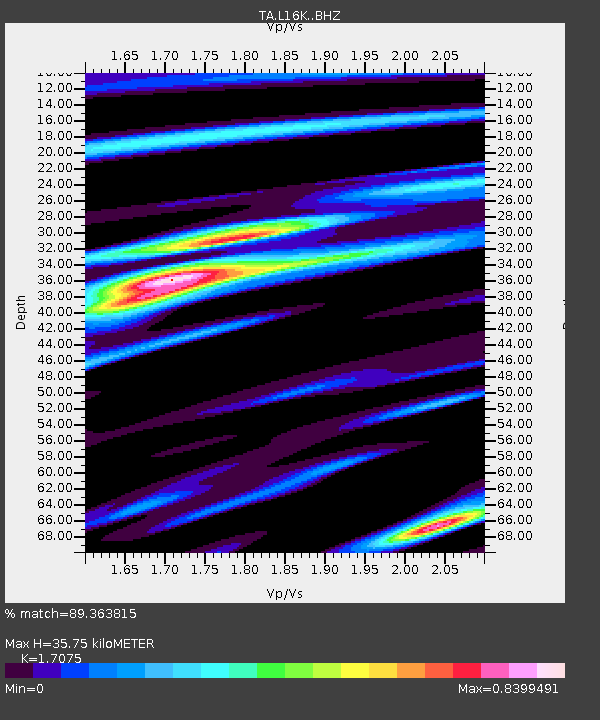
| Estimated Moho Depth: |
35.75 km |
| Estimated Crust Vp/Vs: |
1.71 |
| Assumed Crust Vp: |
6.276 km/s |
| Estimated Crust Vs: |
3.675 km/s |
| Estimated Crust Poisson's Ratio: |
0.24 |
|
| Radial Match: |
89.363815 % |
| Radial Bump: |
400 |
| Transverse Match: |
66.041466 % |
| Transverse Bump: |
400 |
| SOD ConfigId: |
19053131 |
| Insert Time: |
2019-07-29 08:28:53.782 +0000 |
| GWidth: |
2.5 |
| Max Bumps: |
400 |
| Tol: |
0.001 |
|

Signal To Noise
| Channel | StoN | STA | LTA |
| TA:L16K: :BHZ:20190715T08:32:57.224997Z | 7.1938024 | 4.4957181E-7 | 6.249432E-8 |
| TA:L16K: :BHN:20190715T08:32:57.224997Z | 2.3362372 | 1.4584869E-7 | 6.242889E-8 |
| TA:L16K: :BHE:20190715T08:32:57.224997Z | 2.1258464 | 1.9346402E-7 | 9.1005646E-8 |
| Arrivals |
| Ps | 4.2 SECOND |
| PpPs | 15 SECOND |
| PsPs/PpSs | 19 SECOND |


