You are here: Home > Network List > TA - USArray Transportable Network (new EarthScope stations) Stations List
> Station M17K Holitna River, AK, USA > Earthquake Result Viewer
M17K Holitna River, AK, USA - Earthquake Result Viewer
| Earthquake location: |
New Britain Region, P.N.G. |
| Earthquake latitude/longitude: |
-6.0/149.6 |
| Earthquake time(UTC): |
2019/07/15 (196) 08:21:35 GMT |
| Earthquake Depth: |
59 km |
| Earthquake Magnitude: |
6.2 Mww |
| Earthquake Catalog/Contributor: |
NEIC PDE/us |
|
| Network: |
TA USArray Transportable Network (new EarthScope stations) |
| Station: |
M17K Holitna River, AK, USA |
| Lat/Lon: |
61.40 N/157.44 W |
| Elevation: |
387 m |
|
| Distance: |
78.6 deg |
| Az: |
23.08 deg |
| Baz: |
234.129 deg |
| Ray Param: |
0.049393818 |
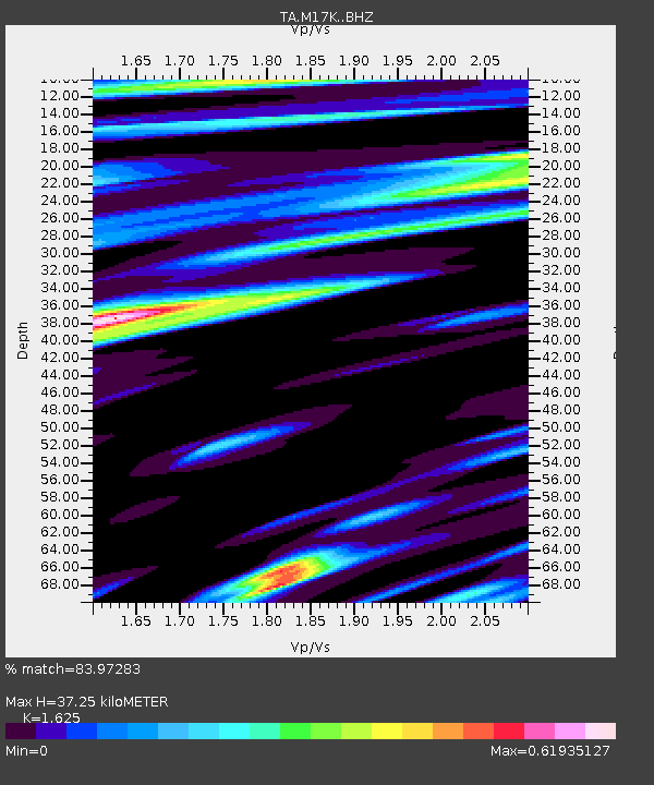
| Estimated Moho Depth: |
37.25 km |
| Estimated Crust Vp/Vs: |
1.62 |
| Assumed Crust Vp: |
6.155 km/s |
| Estimated Crust Vs: |
3.788 km/s |
| Estimated Crust Poisson's Ratio: |
0.20 |
|
| Radial Match: |
83.97283 % |
| Radial Bump: |
393 |
| Transverse Match: |
61.79257 % |
| Transverse Bump: |
400 |
| SOD ConfigId: |
19053131 |
| Insert Time: |
2019-07-29 08:29:00.732 +0000 |
| GWidth: |
2.5 |
| Max Bumps: |
400 |
| Tol: |
0.001 |
|

Signal To Noise
| Channel | StoN | STA | LTA |
| TA:M17K: :BHZ:20190715T08:33:00.500021Z | 4.821354 | 4.960359E-7 | 1.0288312E-7 |
| TA:M17K: :BHN:20190715T08:33:00.500021Z | 1.6378816 | 1.6329562E-7 | 9.9699285E-8 |
| TA:M17K: :BHE:20190715T08:33:00.500021Z | 2.5363626 | 1.88129E-7 | 7.4172746E-8 |
| Arrivals |
| Ps | 3.9 SECOND |
| PpPs | 15 SECOND |
| PsPs/PpSs | 19 SECOND |


