You are here: Home > Network List > TA - USArray Transportable Network (new EarthScope stations) Stations List
> Station V11A Goodsprings, NV, USA > Earthquake Result Viewer
V11A Goodsprings, NV, USA - Earthquake Result Viewer

| Earthquake location: |
Near Coast Of Central Chile |
| Earthquake latitude/longitude: |
-31.3/-71.3 |
| Earthquake time(UTC): |
2006/10/12 (285) 18:05:58 GMT |
| Earthquake Depth: |
46 km |
| Earthquake Magnitude: |
5.8 MB, 6.1 MS, 6.4 MW, 6.3 MW |
| Earthquake Catalog/Contributor: |
WHDF/NEIC |
|
| Network: |
TA USArray Transportable Network (new EarthScope stations) |
| Station: |
V11A Goodsprings, NV, USA |
| Lat/Lon: |
35.84 N/115.43 W |
| Elevation: |
1117 m |
|
| Distance: |
78.6 deg |
| Az: |
324.767 deg |
| Baz: |
142.573 deg |
| Ray Param: |
0.049469374 |
| Estimated Moho Depth: |
27.25 km |
| Estimated Crust Vp/Vs: |
1.82 |
| Assumed Crust Vp: |
6.276 km/s |
| Estimated Crust Vs: |
3.458 km/s |
| Estimated Crust Poisson's Ratio: |
0.28 |
|
| Radial Match: |
90.42109 % |
| Radial Bump: |
400 |
| Transverse Match: |
74.22241 % |
| Transverse Bump: |
400 |
| SOD ConfigId: |
2564 |
| Insert Time: |
2010-03-07 01:54:39.735 +0000 |
| GWidth: |
2.5 |
| Max Bumps: |
400 |
| Tol: |
0.001 |
|
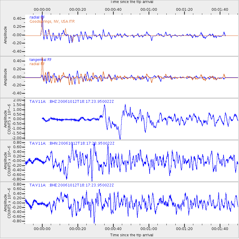
Signal To Noise
| Channel | StoN | STA | LTA |
| TA:V11A: :BHN:20061012T18:17:23.950022Z | 1.7032089 | 1.23029E-7 | 7.2233654E-8 |
| TA:V11A: :BHE:20061012T18:17:23.950022Z | 0.61194545 | 7.2575745E-8 | 1.1859839E-7 |
| TA:V11A: :BHZ:20061012T18:17:23.950022Z | 4.42301 | 3.8481798E-7 | 8.700364E-8 |
| Arrivals |
| Ps | 3.6 SECOND |
| PpPs | 12 SECOND |
| PsPs/PpSs | 16 SECOND |


