You are here: Home > Network List > TA - USArray Transportable Network (new EarthScope stations) Stations List
> Station O17K Koliganek, Bristol Bay, AK, USA > Earthquake Result Viewer
O17K Koliganek, Bristol Bay, AK, USA - Earthquake Result Viewer
| Earthquake location: |
New Britain Region, P.N.G. |
| Earthquake latitude/longitude: |
-6.0/149.6 |
| Earthquake time(UTC): |
2019/07/15 (196) 08:21:35 GMT |
| Earthquake Depth: |
59 km |
| Earthquake Magnitude: |
6.2 Mww |
| Earthquake Catalog/Contributor: |
NEIC PDE/us |
|
| Network: |
TA USArray Transportable Network (new EarthScope stations) |
| Station: |
O17K Koliganek, Bristol Bay, AK, USA |
| Lat/Lon: |
59.77 N/157.09 W |
| Elevation: |
156 m |
|
| Distance: |
77.8 deg |
| Az: |
24.537 deg |
| Baz: |
234.724 deg |
| Ray Param: |
0.04994473 |
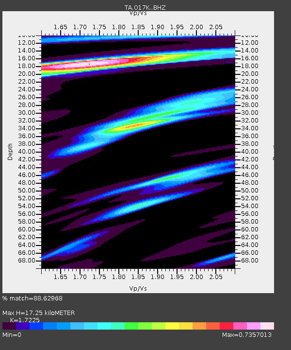
| Estimated Moho Depth: |
17.25 km |
| Estimated Crust Vp/Vs: |
1.72 |
| Assumed Crust Vp: |
6.276 km/s |
| Estimated Crust Vs: |
3.643 km/s |
| Estimated Crust Poisson's Ratio: |
0.25 |
|
| Radial Match: |
88.62968 % |
| Radial Bump: |
309 |
| Transverse Match: |
56.710167 % |
| Transverse Bump: |
400 |
| SOD ConfigId: |
19053131 |
| Insert Time: |
2019-07-29 08:29:13.580 +0000 |
| GWidth: |
2.5 |
| Max Bumps: |
400 |
| Tol: |
0.001 |
|
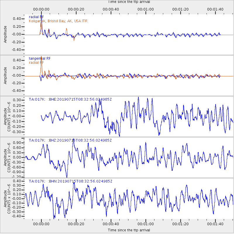
Signal To Noise
| Channel | StoN | STA | LTA |
| TA:O17K: :BHZ:20190715T08:32:56.024985Z | 5.1651387 | 5.0433533E-7 | 9.7642165E-8 |
| TA:O17K: :BHN:20190715T08:32:56.024985Z | 2.297704 | 1.6777692E-7 | 7.301938E-8 |
| TA:O17K: :BHE:20190715T08:32:56.024985Z | 3.542101 | 1.8899696E-7 | 5.3357308E-8 |
| Arrivals |
| Ps | 2.0 SECOND |
| PpPs | 7.3 SECOND |
| PsPs/PpSs | 9.3 SECOND |


