You are here: Home > Network List > TA - USArray Transportable Network (new EarthScope stations) Stations List
> Station R33M Jennings River, BC, CAN > Earthquake Result Viewer
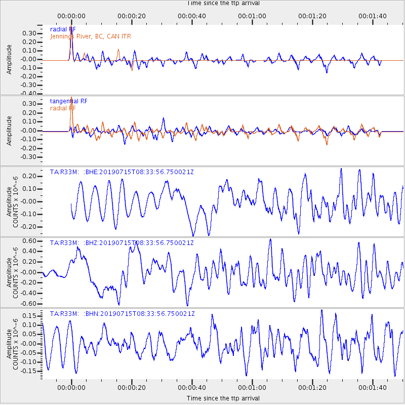
R33M Jennings River, BC, CAN - Earthquake Result Viewer
*The percent match for this event was below the threshold and hence no stack was calculated.
| Earthquake location: |
New Britain Region, P.N.G. |
| Earthquake latitude/longitude: |
-6.0/149.6 |
| Earthquake time(UTC): |
2019/07/15 (196) 08:21:35 GMT |
| Earthquake Depth: |
59 km |
| Earthquake Magnitude: |
6.2 Mww |
| Earthquake Catalog/Contributor: |
NEIC PDE/us |
|
| Network: |
TA USArray Transportable Network (new EarthScope stations) |
| Station: |
R33M Jennings River, BC, CAN |
| Lat/Lon: |
59.39 N/130.97 W |
| Elevation: |
1437 m |
|
| Distance: |
89.8 deg |
| Az: |
30.203 deg |
| Baz: |
257.933 deg |
| Ray Param: |
$rayparam |
*The percent match for this event was below the threshold and hence was not used in the summary stack. |
|
| Radial Match: |
74.96947 % |
| Radial Bump: |
339 |
| Transverse Match: |
59.40938 % |
| Transverse Bump: |
400 |
| SOD ConfigId: |
19053131 |
| Insert Time: |
2019-07-29 08:29:25.635 +0000 |
| GWidth: |
2.5 |
| Max Bumps: |
400 |
| Tol: |
0.001 |
|
Signal To Noise
| Channel | StoN | STA | LTA |
| TA:R33M: :BHZ:20190715T08:33:56.750021Z | 4.5746393 | 3.1474113E-7 | 6.8801306E-8 |
| TA:R33M: :BHN:20190715T08:33:56.750021Z | 0.9843027 | 8.602431E-8 | 8.7396195E-8 |
| TA:R33M: :BHE:20190715T08:33:56.750021Z | 1.034661 | 1.08315525E-7 | 1.0468696E-7 |
| Arrivals |
| Ps | |
| PpPs | |
| PsPs/PpSs | |


