You are here: Home > Network List > TA - USArray Transportable Network (new EarthScope stations) Stations List
> Station S31K Pelican, AK, USA > Earthquake Result Viewer
S31K Pelican, AK, USA - Earthquake Result Viewer
| Earthquake location: |
New Britain Region, P.N.G. |
| Earthquake latitude/longitude: |
-6.0/149.6 |
| Earthquake time(UTC): |
2019/07/15 (196) 08:21:35 GMT |
| Earthquake Depth: |
59 km |
| Earthquake Magnitude: |
6.2 Mww |
| Earthquake Catalog/Contributor: |
NEIC PDE/us |
|
| Network: |
TA USArray Transportable Network (new EarthScope stations) |
| Station: |
S31K Pelican, AK, USA |
| Lat/Lon: |
57.96 N/136.23 W |
| Elevation: |
34 m |
|
| Distance: |
86.8 deg |
| Az: |
30.915 deg |
| Baz: |
253.464 deg |
| Ray Param: |
0.043709118 |
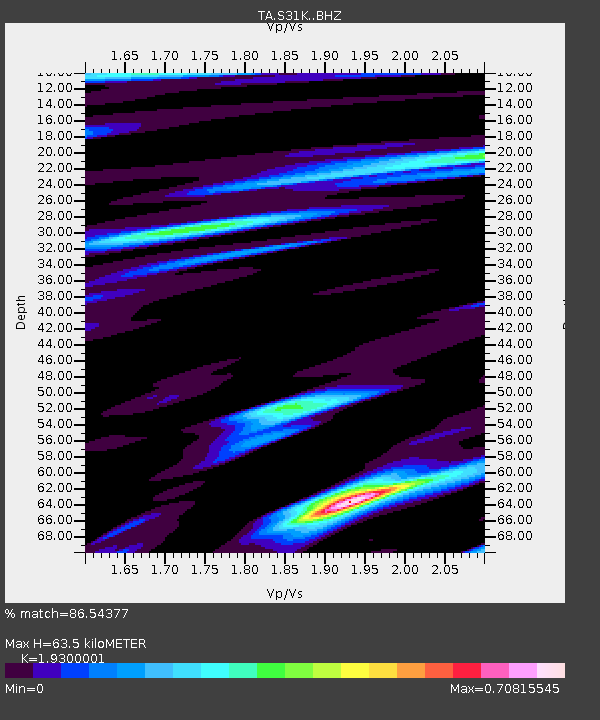
| Estimated Moho Depth: |
63.5 km |
| Estimated Crust Vp/Vs: |
1.93 |
| Assumed Crust Vp: |
6.134 km/s |
| Estimated Crust Vs: |
3.178 km/s |
| Estimated Crust Poisson's Ratio: |
0.32 |
|
| Radial Match: |
86.54377 % |
| Radial Bump: |
400 |
| Transverse Match: |
63.382042 % |
| Transverse Bump: |
400 |
| SOD ConfigId: |
19053131 |
| Insert Time: |
2019-07-29 08:29:26.565 +0000 |
| GWidth: |
2.5 |
| Max Bumps: |
400 |
| Tol: |
0.001 |
|

Signal To Noise
| Channel | StoN | STA | LTA |
| TA:S31K: :BHZ:20190715T08:33:42.474997Z | 6.3388605 | 3.80981E-7 | 6.0102444E-8 |
| TA:S31K: :BHN:20190715T08:33:42.474997Z | 0.9592127 | 5.95559E-8 | 6.208832E-8 |
| TA:S31K: :BHE:20190715T08:33:42.474997Z | 2.4517796 | 1.514903E-7 | 6.178789E-8 |
| Arrivals |
| Ps | 9.8 SECOND |
| PpPs | 30 SECOND |
| PsPs/PpSs | 40 SECOND |


