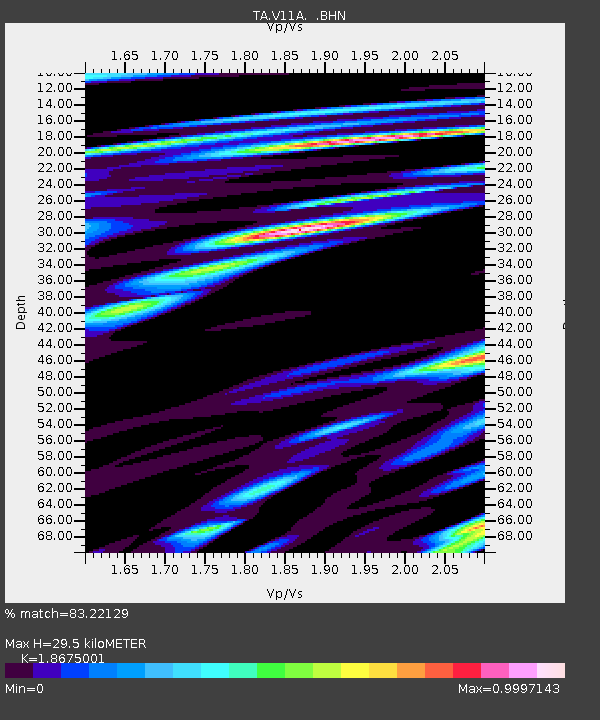
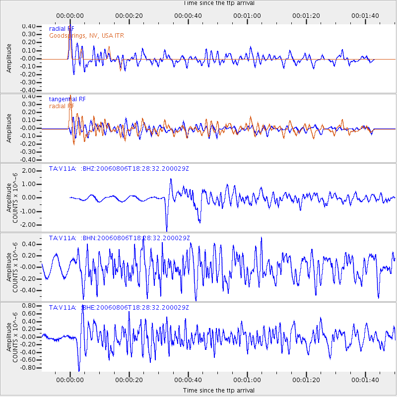
V11A Goodsprings, NV, USA - Earthquake Result Viewer

Earthquake location: Bonin Islands, Japan Region
Earthquake latitude/longitude: 26.1/144.0
Earthquake time(UTC): 2006/08/06 (218) 18:16:40 GMT
Earthquake Depth: 23 km
Earthquake Magnitude: 6.0 MB, 5.6 MS, 5.8 MW, 5.8 MW
Earthquake Catalog/Contributor: WHDF/NEIC
Network: TA USArray Transportable Network (new EarthScope stations)
Station: V11A Goodsprings, NV, USA
Lat/Lon: 35.84 N/115.43 W
Elevation: 1117 m
Distance: 83.0 deg
Az: 53.583 deg
Baz: 297.078 deg
Ray Param: 0.046452146
Estimated Moho Depth: 29.5 km
Estimated Crust Vp/Vs: 1.87
Assumed Crust Vp: 6.276 km/s
Estimated Crust Vs: 3.361 km/s
Estimated Crust Poisson's Ratio: 0.30
Radial Match: 83.22129 %
Radial Bump: 400
Transverse Match: 67.737404 %
Transverse Bump: 400
SOD ConfigId: 2665
Insert Time: 2010-03-07 01:54:56.737 +0000
GWidth: 2.5
Max Bumps: 400
Tol: 0.001

Signal To Noise

ChannelStoNSTALTA
TA:V11A: :BHN:20060806T18:28:32.200029Z2.32823732.108496E-79.0561905E-8
TA:V11A: :BHE:20060806T18:28:32.200029Z3.8359583.8189322E-79.955615E-8
TA:V11A: :BHZ:20060806T18:28:32.200029Z5.73013938.3034575E-71.4490848E-7
Arrivals
Ps4.2 SECOND
PpPs13 SECOND
PsPs/PpSs17 SECOND