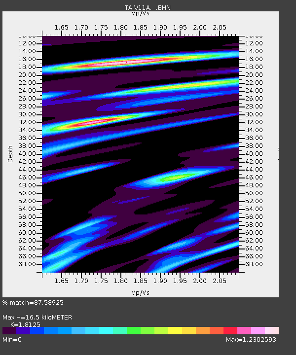
V11A Goodsprings, NV, USA - Earthquake Result Viewer
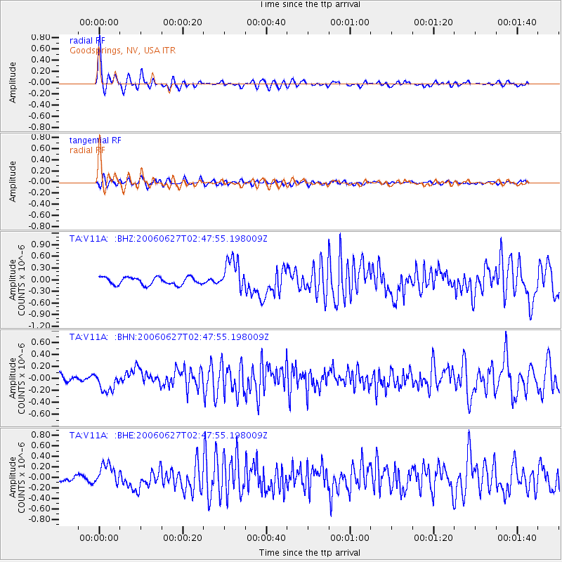
Earthquake location: Rat Islands, Aleutian Islands
Earthquake latitude/longitude: 52.2/176.2
Earthquake time(UTC): 2006/06/27 (178) 02:39:35 GMT
Earthquake Depth: 34 km
Earthquake Magnitude: 5.6 MB, 6.0 MS, 6.2 MW, 6.2 MW
Earthquake Catalog/Contributor: WHDF/NEIC
Network: TA USArray Transportable Network (new EarthScope stations)
Station: V11A Goodsprings, NV, USA
Lat/Lon: 35.84 N/115.43 W
Elevation: 1117 m
Distance: 49.9 deg
Az: 80.765 deg
Baz: 311.619 deg
Ray Param: 0.06832024
Estimated Moho Depth: 16.5 km
Estimated Crust Vp/Vs: 1.81
Assumed Crust Vp: 6.276 km/s
Estimated Crust Vs: 3.463 km/s
Estimated Crust Poisson's Ratio: 0.28
Radial Match: 87.58925 %
Radial Bump: 400
Transverse Match: 69.56397 %
Transverse Bump: 400
SOD ConfigId: 2665
Insert Time: 2010-03-07 01:55:02.950 +0000
GWidth: 2.5
Max Bumps: 400
Tol: 0.001

Signal To Noise

ChannelStoNSTALTA
TA:V11A: :BHN:20060627T02:47:55.198009Z3.01178381.6067534E-75.33489E-8
TA:V11A: :BHE:20060627T02:47:55.198009Z2.95742751.987549E-76.7205335E-8
TA:V11A: :BHZ:20060627T02:47:55.198009Z4.4120854.229368E-79.585872E-8
Arrivals
Ps2.3 SECOND
PpPs7.0 SECOND
PsPs/PpSs9.3 SECOND