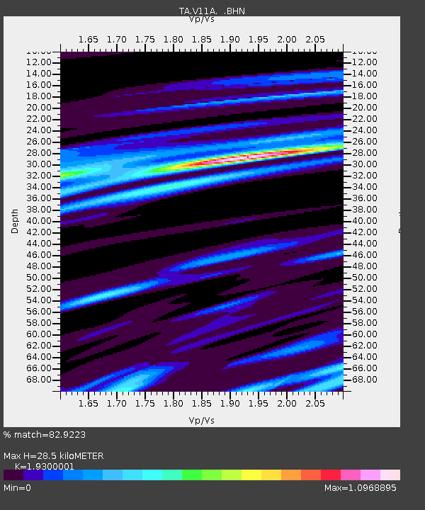
V11A Goodsprings, NV, USA - Earthquake Result Viewer
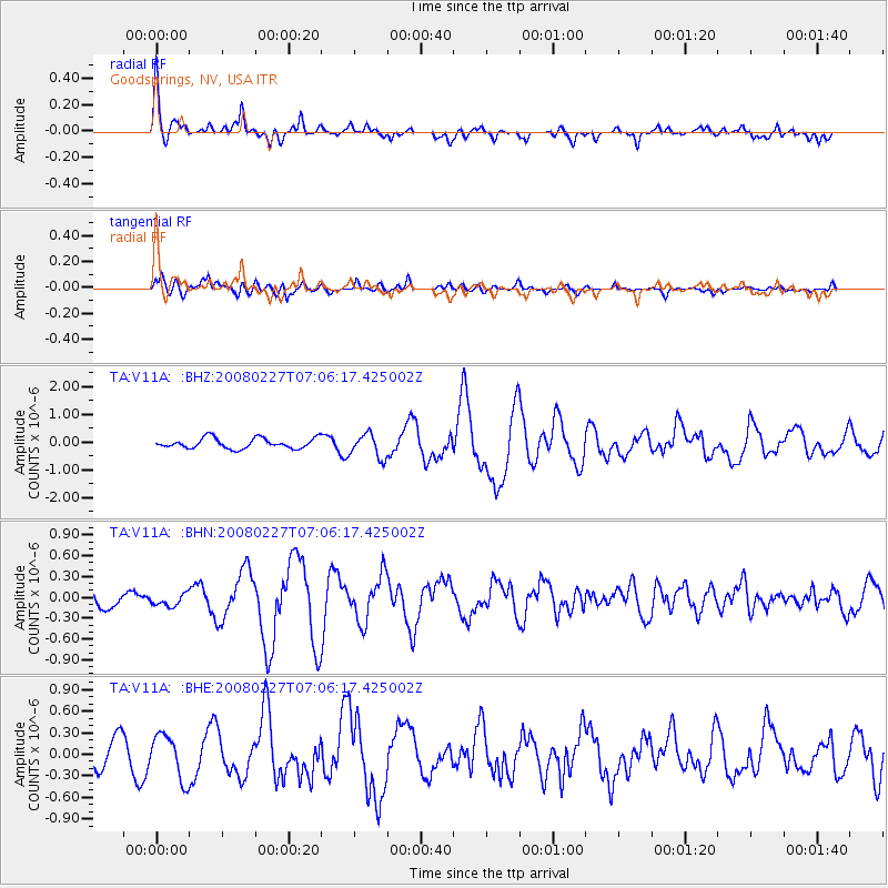
Earthquake location: Bonin Islands, Japan Region
Earthquake latitude/longitude: 26.8/142.4
Earthquake time(UTC): 2008/02/27 (058) 06:54:20 GMT
Earthquake Depth: 15 km
Earthquake Magnitude: 5.8 MB, 6.1 MS, 6.2 MW, 6.2 MW
Earthquake Catalog/Contributor: WHDF/NEIC
Network: TA USArray Transportable Network (new EarthScope stations)
Station: V11A Goodsprings, NV, USA
Lat/Lon: 35.84 N/115.43 W
Elevation: 1117 m
Distance: 83.7 deg
Az: 53.049 deg
Baz: 298.484 deg
Ray Param: 0.045960963
Estimated Moho Depth: 28.5 km
Estimated Crust Vp/Vs: 1.93
Assumed Crust Vp: 6.276 km/s
Estimated Crust Vs: 3.252 km/s
Estimated Crust Poisson's Ratio: 0.32
Radial Match: 82.9223 %
Radial Bump: 400
Transverse Match: 67.48123 %
Transverse Bump: 400
SOD ConfigId: 2564
Insert Time: 2010-03-07 01:55:12.812 +0000
GWidth: 2.5
Max Bumps: 400
Tol: 0.001

Signal To Noise

ChannelStoNSTALTA
TA:V11A: :BHN:20080227T07:06:17.425002Z0.435047338.781833E-82.0185927E-7
TA:V11A: :BHE:20080227T07:06:17.425002Z1.82300873.0978237E-71.6992918E-7
TA:V11A: :BHZ:20080227T07:06:17.425002Z2.32979234.3460682E-71.8654316E-7
Arrivals
Ps4.3 SECOND
PpPs13 SECOND
PsPs/PpSs17 SECOND