You are here: Home > Network List > TA - USArray Transportable Network (new EarthScope stations) Stations List
> Station V12A Nelson, NV, USA > Earthquake Result Viewer
V12A Nelson, NV, USA - Earthquake Result Viewer
| Earthquake location: |
Near West Coast Of Colombia |
| Earthquake latitude/longitude: |
3.0/-78.0 |
| Earthquake time(UTC): |
2007/09/10 (253) 01:49:14 GMT |
| Earthquake Depth: |
31 km |
| Earthquake Magnitude: |
6.1 MB, 6.7 MS, 6.8 MW |
| Earthquake Catalog/Contributor: |
WHDF/NEIC |
|
| Network: |
TA USArray Transportable Network (new EarthScope stations) |
| Station: |
V12A Nelson, NV, USA |
| Lat/Lon: |
35.73 N/114.85 W |
| Elevation: |
1098 m |
|
| Distance: |
47.2 deg |
| Az: |
318.238 deg |
| Baz: |
125.167 deg |
| Ray Param: |
0.07011565 |
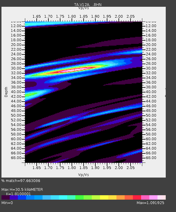
| Estimated Moho Depth: |
30.5 km |
| Estimated Crust Vp/Vs: |
1.81 |
| Assumed Crust Vp: |
6.276 km/s |
| Estimated Crust Vs: |
3.467 km/s |
| Estimated Crust Poisson's Ratio: |
0.28 |
|
| Radial Match: |
97.663086 % |
| Radial Bump: |
258 |
| Transverse Match: |
87.685425 % |
| Transverse Bump: |
400 |
| SOD ConfigId: |
2564 |
| Insert Time: |
2010-03-07 01:55:32.173 +0000 |
| GWidth: |
2.5 |
| Max Bumps: |
400 |
| Tol: |
0.001 |
|
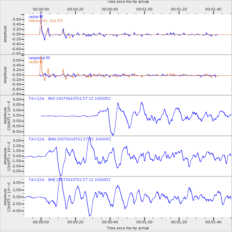
Signal To Noise
| Channel | StoN | STA | LTA |
| TA:V12A: :BHN:20070910T01:57:13.100005Z | 6.331843 | 4.6528743E-7 | 7.348373E-8 |
| TA:V12A: :BHE:20070910T01:57:13.100005Z | 6.621203 | 7.4308383E-7 | 1.12227916E-7 |
| TA:V12A: :BHZ:20070910T01:57:13.100005Z | 10.513158 | 1.3287602E-6 | 1.263902E-7 |
| Arrivals |
| Ps | 4.2 SECOND |
| PpPs | 13 SECOND |
| PsPs/PpSs | 17 SECOND |


