You are here: Home > Network List > TA - USArray Transportable Network (new EarthScope stations) Stations List
> Station V12A Nelson, NV, USA > Earthquake Result Viewer
V12A Nelson, NV, USA - Earthquake Result Viewer
| Earthquake location: |
Peru-Brazil Border Region |
| Earthquake latitude/longitude: |
-7.9/-74.4 |
| Earthquake time(UTC): |
2007/07/12 (193) 05:23:49 GMT |
| Earthquake Depth: |
152 km |
| Earthquake Magnitude: |
5.9 MB, 6.1 MW, 6.0 MW |
| Earthquake Catalog/Contributor: |
WHDF/NEIC |
|
| Network: |
TA USArray Transportable Network (new EarthScope stations) |
| Station: |
V12A Nelson, NV, USA |
| Lat/Lon: |
35.73 N/114.85 W |
| Elevation: |
1098 m |
|
| Distance: |
57.8 deg |
| Az: |
321.363 deg |
| Baz: |
130.525 deg |
| Ray Param: |
0.06280449 |
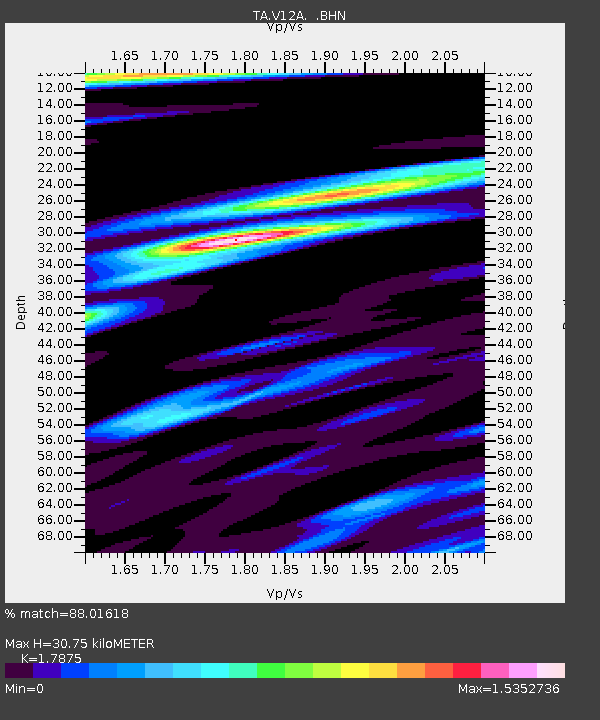
| Estimated Moho Depth: |
30.75 km |
| Estimated Crust Vp/Vs: |
1.79 |
| Assumed Crust Vp: |
6.276 km/s |
| Estimated Crust Vs: |
3.511 km/s |
| Estimated Crust Poisson's Ratio: |
0.27 |
|
| Radial Match: |
88.01618 % |
| Radial Bump: |
400 |
| Transverse Match: |
68.15485 % |
| Transverse Bump: |
400 |
| SOD ConfigId: |
2564 |
| Insert Time: |
2010-03-07 01:56:09.734 +0000 |
| GWidth: |
2.5 |
| Max Bumps: |
400 |
| Tol: |
0.001 |
|
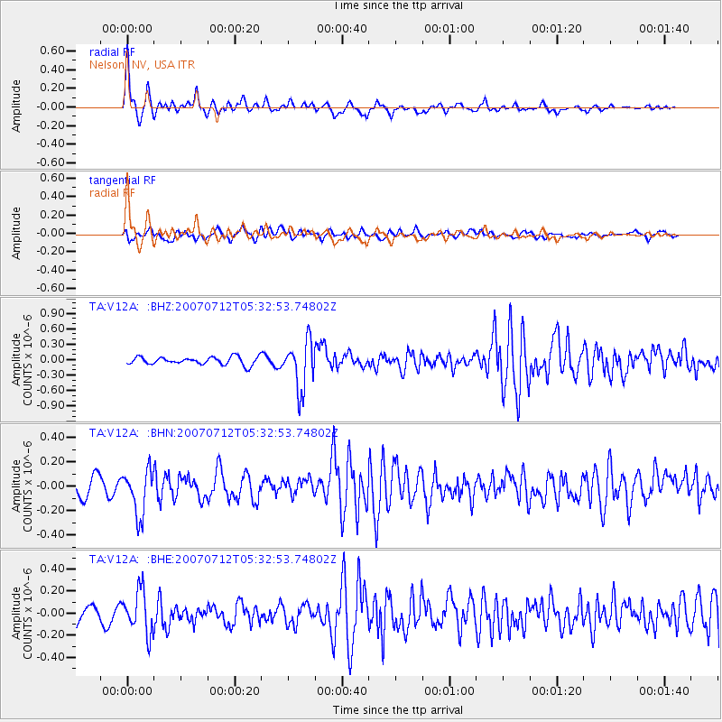
Signal To Noise
| Channel | StoN | STA | LTA |
| TA:V12A: :BHN:20070712T05:32:53.74802Z | 2.7430215 | 1.8519096E-7 | 6.751349E-8 |
| TA:V12A: :BHE:20070712T05:32:53.74802Z | 3.0075996 | 1.9181918E-7 | 6.377817E-8 |
| TA:V12A: :BHZ:20070712T05:32:53.74802Z | 6.3068995 | 4.727408E-7 | 7.4956134E-8 |
| Arrivals |
| Ps | 4.0 SECOND |
| PpPs | 13 SECOND |
| PsPs/PpSs | 17 SECOND |


