You are here: Home > Network List > AV - Alaska Volcano Observatory Stations List
> Station MAPS Pakushin Southeast, Makushin Volcano, Alaska > Earthquake Result Viewer
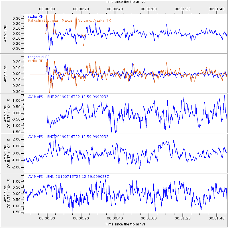
MAPS Pakushin Southeast, Makushin Volcano, Alaska - Earthquake Result Viewer
*The percent match for this event was below the threshold and hence no stack was calculated.
| Earthquake location: |
South Of Mariana Islands |
| Earthquake latitude/longitude: |
12.3/144.8 |
| Earthquake time(UTC): |
2019/07/16 (197) 22:03:54 GMT |
| Earthquake Depth: |
34 km |
| Earthquake Magnitude: |
5.7 Mi |
| Earthquake Catalog/Contributor: |
NEIC PDE/pt |
|
| Network: |
AV Alaska Volcano Observatory |
| Station: |
MAPS Pakushin Southeast, Makushin Volcano, Alaska |
| Lat/Lon: |
53.81 N/166.94 W |
| Elevation: |
333 m |
|
| Distance: |
56.2 deg |
| Az: |
32.171 deg |
| Baz: |
241.339 deg |
| Ray Param: |
$rayparam |
*The percent match for this event was below the threshold and hence was not used in the summary stack. |
|
| Radial Match: |
46.01137 % |
| Radial Bump: |
400 |
| Transverse Match: |
49.328434 % |
| Transverse Bump: |
400 |
| SOD ConfigId: |
19053131 |
| Insert Time: |
2019-07-30 22:06:33.056 +0000 |
| GWidth: |
2.5 |
| Max Bumps: |
400 |
| Tol: |
0.001 |
|
Signal To Noise
| Channel | StoN | STA | LTA |
| AV:MAPS: :BHZ:20190716T22:12:59.999023Z | 1.8575535 | 1.2798922E-6 | 6.890204E-7 |
| AV:MAPS: :BHN:20190716T22:12:59.999023Z | 2.2145486 | 5.9602735E-7 | 2.6914168E-7 |
| AV:MAPS: :BHE:20190716T22:12:59.999023Z | 1.4411451 | 6.509371E-7 | 4.5168048E-7 |
| Arrivals |
| Ps | |
| PpPs | |
| PsPs/PpSs | |


