You are here: Home > Network List > TA - USArray Transportable Network (new EarthScope stations) Stations List
> Station V12A Nelson, NV, USA > Earthquake Result Viewer
V12A Nelson, NV, USA - Earthquake Result Viewer
| Earthquake location: |
Near Coast Of Guatemala |
| Earthquake latitude/longitude: |
14.0/-91.2 |
| Earthquake time(UTC): |
2006/12/03 (337) 20:52:15 GMT |
| Earthquake Depth: |
61 km |
| Earthquake Magnitude: |
5.8 MB, 5.9 MW, 5.9 MW |
| Earthquake Catalog/Contributor: |
WHDF/NEIC |
|
| Network: |
TA USArray Transportable Network (new EarthScope stations) |
| Station: |
V12A Nelson, NV, USA |
| Lat/Lon: |
35.73 N/114.85 W |
| Elevation: |
1098 m |
|
| Distance: |
30.3 deg |
| Az: |
319.73 deg |
| Baz: |
129.543 deg |
| Ray Param: |
0.07927681 |
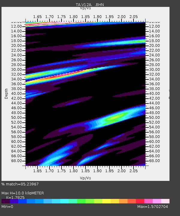
| Estimated Moho Depth: |
10.0 km |
| Estimated Crust Vp/Vs: |
1.78 |
| Assumed Crust Vp: |
6.276 km/s |
| Estimated Crust Vs: |
3.521 km/s |
| Estimated Crust Poisson's Ratio: |
0.27 |
|
| Radial Match: |
85.23967 % |
| Radial Bump: |
400 |
| Transverse Match: |
79.46924 % |
| Transverse Bump: |
400 |
| SOD ConfigId: |
2564 |
| Insert Time: |
2010-03-07 01:56:22.928 +0000 |
| GWidth: |
2.5 |
| Max Bumps: |
400 |
| Tol: |
0.001 |
|
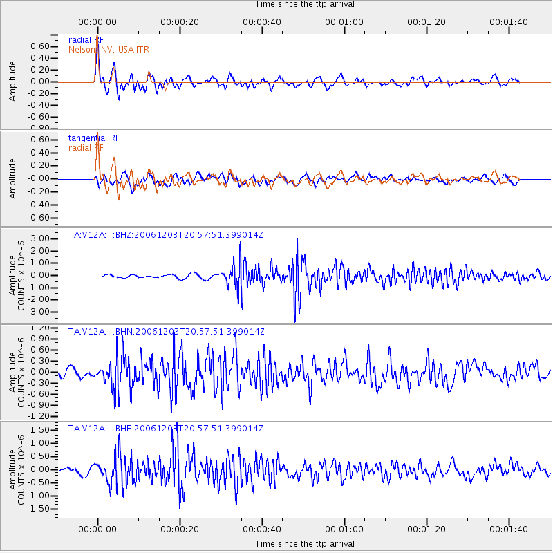
Signal To Noise
| Channel | StoN | STA | LTA |
| TA:V12A: :BHN:20061203T20:57:51.399014Z | 3.5712337 | 3.4391914E-7 | 9.6302614E-8 |
| TA:V12A: :BHE:20061203T20:57:51.399014Z | 5.565549 | 4.2729218E-7 | 7.677449E-8 |
| TA:V12A: :BHZ:20061203T20:57:51.399014Z | 6.299899 | 9.086793E-7 | 1.442371E-7 |
| Arrivals |
| Ps | 1.3 SECOND |
| PpPs | 4.1 SECOND |
| PsPs/PpSs | 5.5 SECOND |


