You are here: Home > Network List > AV - Alaska Volcano Observatory Stations List
> Station GSIG Igitkin Island, Great Sitkin Volcano, Alaska > Earthquake Result Viewer
GSIG Igitkin Island, Great Sitkin Volcano, Alaska - Earthquake Result Viewer
| Earthquake location: |
South Of Mariana Islands |
| Earthquake latitude/longitude: |
12.3/144.8 |
| Earthquake time(UTC): |
2019/07/16 (197) 22:03:54 GMT |
| Earthquake Depth: |
34 km |
| Earthquake Magnitude: |
5.7 Mi |
| Earthquake Catalog/Contributor: |
NEIC PDE/pt |
|
| Network: |
AV Alaska Volcano Observatory |
| Station: |
GSIG Igitkin Island, Great Sitkin Volcano, Alaska |
| Lat/Lon: |
51.99 N/175.93 W |
| Elevation: |
407 m |
|
| Distance: |
50.6 deg |
| Az: |
30.412 deg |
| Baz: |
233.134 deg |
| Ray Param: |
0.06784925 |
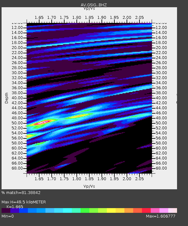
| Estimated Moho Depth: |
49.5 km |
| Estimated Crust Vp/Vs: |
1.66 |
| Assumed Crust Vp: |
3.943 km/s |
| Estimated Crust Vs: |
2.368 km/s |
| Estimated Crust Poisson's Ratio: |
0.22 |
|
| Radial Match: |
81.38842 % |
| Radial Bump: |
400 |
| Transverse Match: |
68.92824 % |
| Transverse Bump: |
400 |
| SOD ConfigId: |
19053131 |
| Insert Time: |
2019-07-30 22:06:54.687 +0000 |
| GWidth: |
2.5 |
| Max Bumps: |
400 |
| Tol: |
0.001 |
|
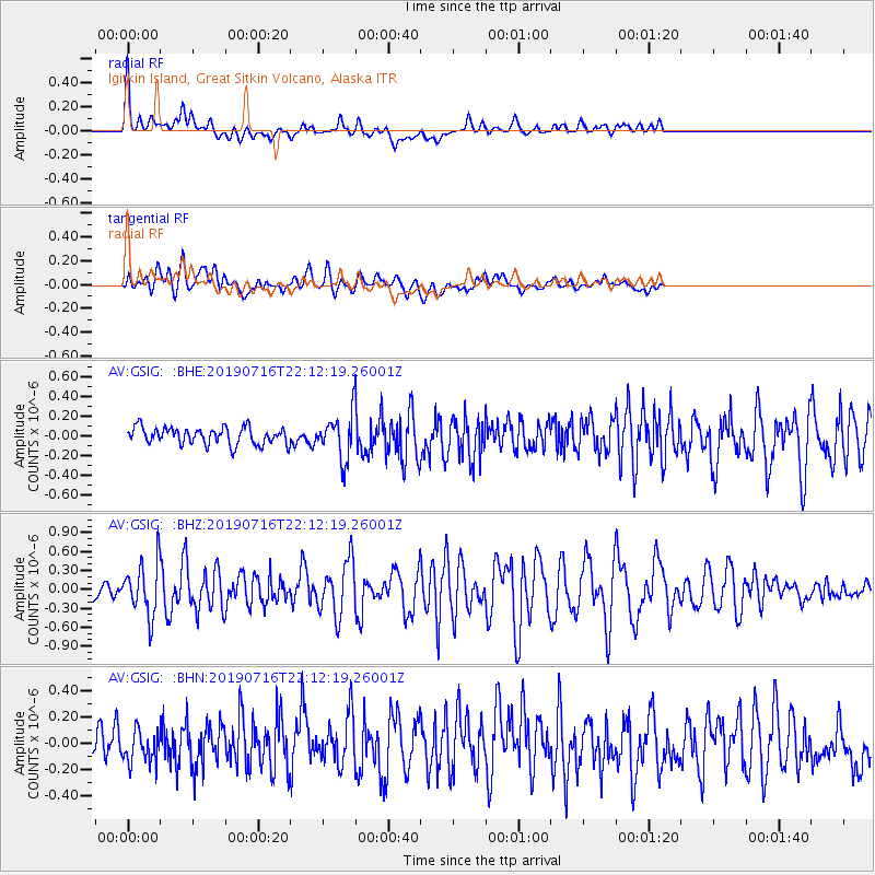
Signal To Noise
| Channel | StoN | STA | LTA |
| AV:GSIG: :BHZ:20190716T22:12:19.26001Z | 5.5397773 | 4.0726047E-7 | 7.351568E-8 |
| AV:GSIG: :BHN:20190716T22:12:19.26001Z | 1.5254586 | 1.1947695E-7 | 7.832199E-8 |
| AV:GSIG: :BHE:20190716T22:12:19.26001Z | 2.5683618 | 2.2028814E-7 | 8.5769905E-8 |
| Arrivals |
| Ps | 8.5 SECOND |
| PpPs | 33 SECOND |
| PsPs/PpSs | 41 SECOND |


