You are here: Home > Network List > TA - USArray Transportable Network (new EarthScope stations) Stations List
> Station V12A Nelson, NV, USA > Earthquake Result Viewer
V12A Nelson, NV, USA - Earthquake Result Viewer
| Earthquake location: |
San Juan Province, Argentina |
| Earthquake latitude/longitude: |
-31.7/-67.2 |
| Earthquake time(UTC): |
2006/09/17 (260) 09:34:14 GMT |
| Earthquake Depth: |
142 km |
| Earthquake Magnitude: |
5.7 MB, 6.2 MW, 6.2 MW |
| Earthquake Catalog/Contributor: |
WHDF/NEIC |
|
| Network: |
TA USArray Transportable Network (new EarthScope stations) |
| Station: |
V12A Nelson, NV, USA |
| Lat/Lon: |
35.73 N/114.85 W |
| Elevation: |
1098 m |
|
| Distance: |
80.7 deg |
| Az: |
322.435 deg |
| Baz: |
140.33 deg |
| Ray Param: |
0.04779762 |
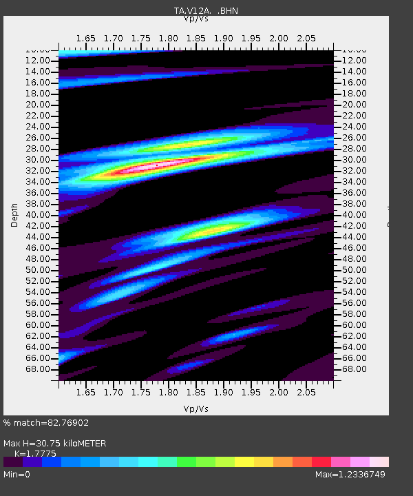
| Estimated Moho Depth: |
30.75 km |
| Estimated Crust Vp/Vs: |
1.78 |
| Assumed Crust Vp: |
6.276 km/s |
| Estimated Crust Vs: |
3.531 km/s |
| Estimated Crust Poisson's Ratio: |
0.27 |
|
| Radial Match: |
82.76902 % |
| Radial Bump: |
400 |
| Transverse Match: |
72.114914 % |
| Transverse Bump: |
400 |
| SOD ConfigId: |
2665 |
| Insert Time: |
2010-03-07 01:56:42.526 +0000 |
| GWidth: |
2.5 |
| Max Bumps: |
400 |
| Tol: |
0.001 |
|
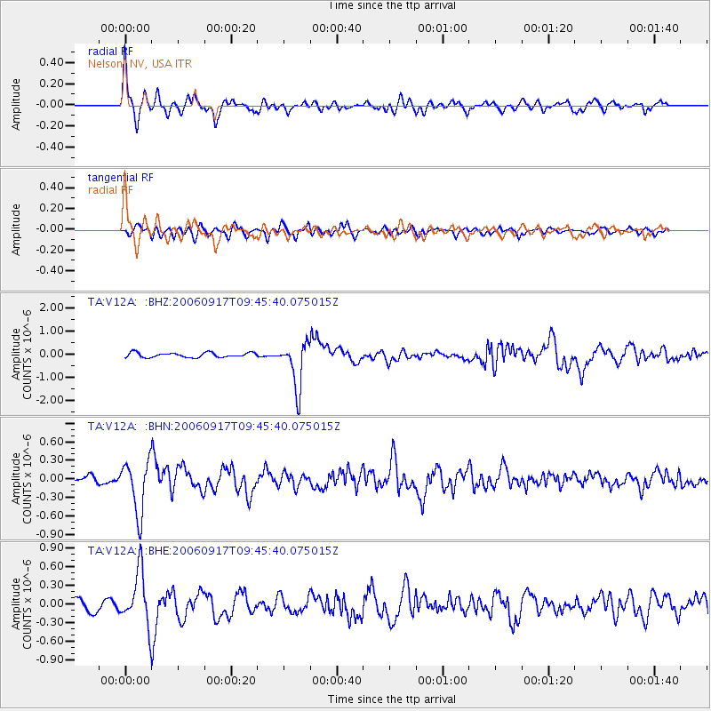
Signal To Noise
| Channel | StoN | STA | LTA |
| TA:V12A: :BHN:20060917T09:45:40.075015Z | 8.007164 | 4.2993773E-7 | 5.3694134E-8 |
| TA:V12A: :BHE:20060917T09:45:40.075015Z | 4.331785 | 4.3527152E-7 | 1.0048317E-7 |
| TA:V12A: :BHZ:20060917T09:45:40.075015Z | 10.133751 | 1.0136552E-6 | 1.00027634E-7 |
| Arrivals |
| Ps | 3.9 SECOND |
| PpPs | 13 SECOND |
| PsPs/PpSs | 17 SECOND |


