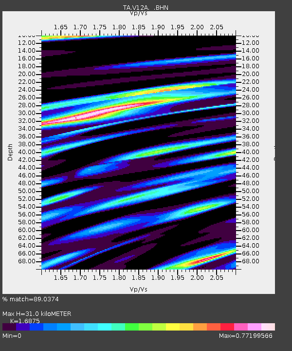
V12A Nelson, NV, USA - Earthquake Result Viewer
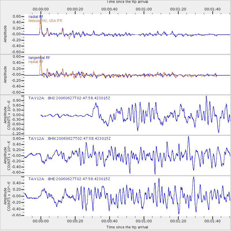
Earthquake location: Rat Islands, Aleutian Islands
Earthquake latitude/longitude: 52.2/176.2
Earthquake time(UTC): 2006/06/27 (178) 02:39:35 GMT
Earthquake Depth: 34 km
Earthquake Magnitude: 5.6 MB, 6.0 MS, 6.2 MW, 6.2 MW
Earthquake Catalog/Contributor: WHDF/NEIC
Network: TA USArray Transportable Network (new EarthScope stations)
Station: V12A Nelson, NV, USA
Lat/Lon: 35.73 N/114.85 W
Elevation: 1098 m
Distance: 50.4 deg
Az: 80.465 deg
Baz: 311.764 deg
Ray Param: 0.068041824
Estimated Moho Depth: 31.0 km
Estimated Crust Vp/Vs: 1.69
Assumed Crust Vp: 6.276 km/s
Estimated Crust Vs: 3.719 km/s
Estimated Crust Poisson's Ratio: 0.23
Radial Match: 89.0374 %
Radial Bump: 400
Transverse Match: 71.230804 %
Transverse Bump: 400
SOD ConfigId: 2665
Insert Time: 2010-03-07 01:56:55.012 +0000
GWidth: 2.5
Max Bumps: 400
Tol: 0.001

Signal To Noise

ChannelStoNSTALTA
TA:V12A: :BHN:20060627T02:47:58.423015Z2.55515531.3768866E-75.3886613E-8
TA:V12A: :BHE:20060627T02:47:58.423015Z2.67452981.3901187E-75.1976194E-8
TA:V12A: :BHZ:20060627T02:47:58.423015Z9.3365114.2189924E-74.518811E-8
Arrivals
Ps3.6 SECOND
PpPs13 SECOND
PsPs/PpSs16 SECOND