You are here: Home > Network List > TA - USArray Transportable Network (new EarthScope stations) Stations List
> Station V12A Nelson, NV, USA > Earthquake Result Viewer
V12A Nelson, NV, USA - Earthquake Result Viewer
| Earthquake location: |
South Of Panama |
| Earthquake latitude/longitude: |
4.6/-78.5 |
| Earthquake time(UTC): |
2007/03/18 (077) 02:11:05 GMT |
| Earthquake Depth: |
8.0 km |
| Earthquake Magnitude: |
6.4 MB, 5.7 MS, 6.2 MW, 6.1 MW |
| Earthquake Catalog/Contributor: |
WHDF/NEIC |
|
| Network: |
TA USArray Transportable Network (new EarthScope stations) |
| Station: |
V12A Nelson, NV, USA |
| Lat/Lon: |
35.73 N/114.85 W |
| Elevation: |
1098 m |
|
| Distance: |
45.6 deg |
| Az: |
317.563 deg |
| Baz: |
124.24 deg |
| Ray Param: |
0.07116452 |
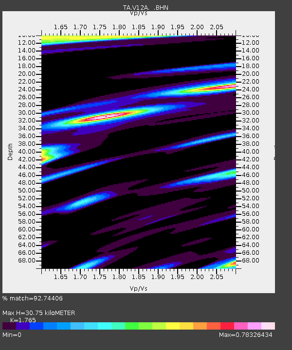
| Estimated Moho Depth: |
30.75 km |
| Estimated Crust Vp/Vs: |
1.76 |
| Assumed Crust Vp: |
6.276 km/s |
| Estimated Crust Vs: |
3.556 km/s |
| Estimated Crust Poisson's Ratio: |
0.26 |
|
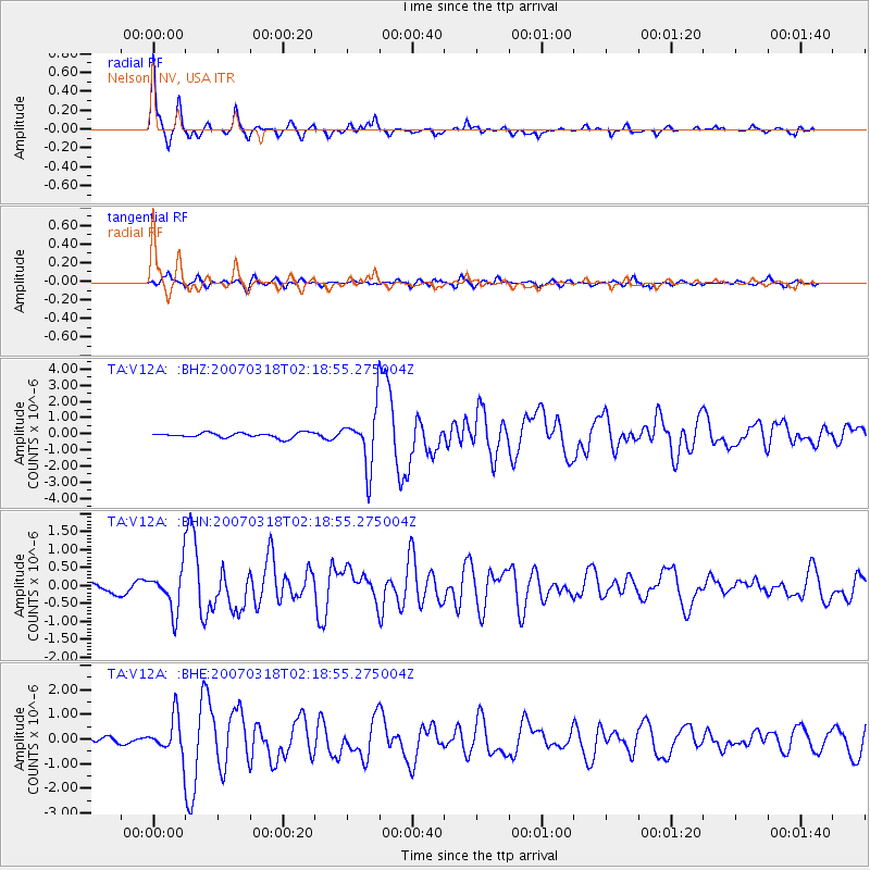
| Radial Match: |
92.74406 % |
| Radial Bump: |
295 |
| Transverse Match: |
79.980774 % |
| Transverse Bump: |
400 |
| SOD ConfigId: |
2564 |
| Insert Time: |
2010-03-07 01:56:59.923 +0000 |
| GWidth: |
2.5 |
| Max Bumps: |
400 |
| Tol: |
0.001 |
|
Signal To Noise
| Channel | StoN | STA | LTA |
| TA:V12A: :BHN:20070318T02:18:55.275004Z | 4.0458007 | 5.791652E-7 | 1.4315219E-7 |
| TA:V12A: :BHE:20070318T02:18:55.275004Z | 6.8480797 | 7.4967676E-7 | 1.0947255E-7 |
| TA:V12A: :BHZ:20070318T02:18:55.275004Z | 11.27977 | 1.7252619E-6 | 1.5295186E-7 |
| Arrivals |
| Ps | 4.0 SECOND |
| PpPs | 13 SECOND |
| PsPs/PpSs | 17 SECOND |


