You are here: Home > Network List > TA - USArray Transportable Network (new EarthScope stations) Stations List
> Station C23K Itkillik River, AK, USA > Earthquake Result Viewer
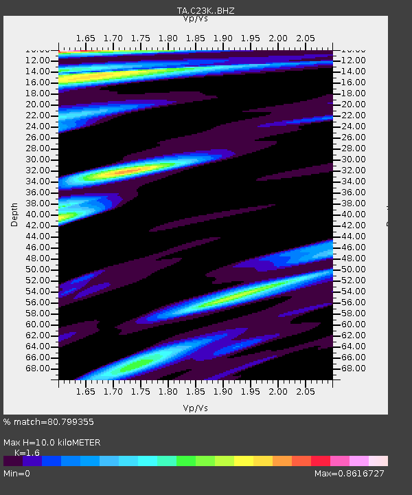
C23K Itkillik River, AK, USA - Earthquake Result Viewer
| Earthquake location: |
South Of Mariana Islands |
| Earthquake latitude/longitude: |
12.3/144.8 |
| Earthquake time(UTC): |
2019/07/16 (197) 22:03:54 GMT |
| Earthquake Depth: |
34 km |
| Earthquake Magnitude: |
5.7 Mi |
| Earthquake Catalog/Contributor: |
NEIC PDE/pt |
|
| Network: |
TA USArray Transportable Network (new EarthScope stations) |
| Station: |
C23K Itkillik River, AK, USA |
| Lat/Lon: |
69.84 N/150.61 W |
| Elevation: |
179 m |
|
| Distance: |
69.9 deg |
| Az: |
19.482 deg |
| Baz: |
250.063 deg |
| Ray Param: |
0.05529251 |
| Estimated Moho Depth: |
10.0 km |
| Estimated Crust Vp/Vs: |
1.60 |
| Assumed Crust Vp: |
6.221 km/s |
| Estimated Crust Vs: |
3.888 km/s |
| Estimated Crust Poisson's Ratio: |
0.18 |
|
| Radial Match: |
80.799355 % |
| Radial Bump: |
400 |
| Transverse Match: |
69.12846 % |
| Transverse Bump: |
400 |
| SOD ConfigId: |
19053131 |
| Insert Time: |
2019-07-30 22:13:06.978 +0000 |
| GWidth: |
2.5 |
| Max Bumps: |
400 |
| Tol: |
0.001 |
|

Signal To Noise
| Channel | StoN | STA | LTA |
| TA:C23K: :BHZ:20190716T22:14:30.625Z | 4.025308 | 6.4104046E-7 | 1.5925252E-7 |
| TA:C23K: :BHN:20190716T22:14:30.625Z | 0.66633976 | 8.0980946E-8 | 1.2153102E-7 |
| TA:C23K: :BHE:20190716T22:14:30.625Z | 0.9696738 | 1.3772014E-7 | 1.4202729E-7 |
| Arrivals |
| Ps | 1.0 SECOND |
| PpPs | 4.0 SECOND |
| PsPs/PpSs | 5.0 SECOND |


