You are here: Home > Network List > TA - USArray Transportable Network (new EarthScope stations) Stations List
> Station E20K Nigu River, AK, USA > Earthquake Result Viewer
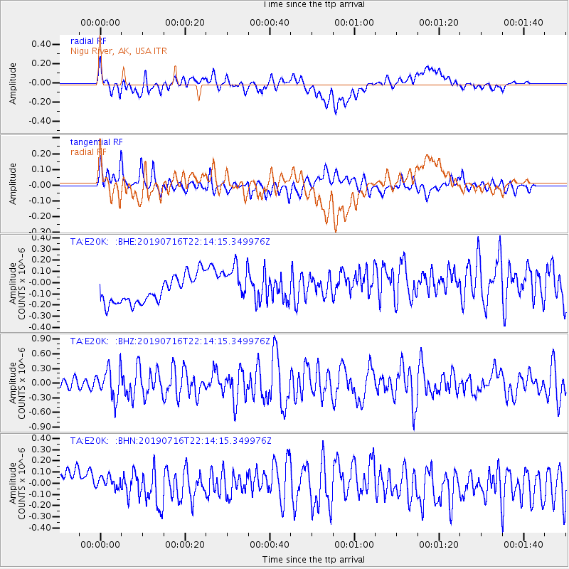
E20K Nigu River, AK, USA - Earthquake Result Viewer
*The percent match for this event was below the threshold and hence no stack was calculated.
| Earthquake location: |
South Of Mariana Islands |
| Earthquake latitude/longitude: |
12.3/144.8 |
| Earthquake time(UTC): |
2019/07/16 (197) 22:03:54 GMT |
| Earthquake Depth: |
34 km |
| Earthquake Magnitude: |
5.7 Mi |
| Earthquake Catalog/Contributor: |
NEIC PDE/pt |
|
| Network: |
TA USArray Transportable Network (new EarthScope stations) |
| Station: |
E20K Nigu River, AK, USA |
| Lat/Lon: |
68.26 N/156.19 W |
| Elevation: |
866 m |
|
| Distance: |
67.4 deg |
| Az: |
20.235 deg |
| Baz: |
245.134 deg |
| Ray Param: |
$rayparam |
*The percent match for this event was below the threshold and hence was not used in the summary stack. |
|
| Radial Match: |
56.971096 % |
| Radial Bump: |
400 |
| Transverse Match: |
77.12307 % |
| Transverse Bump: |
400 |
| SOD ConfigId: |
19053131 |
| Insert Time: |
2019-07-30 22:13:25.141 +0000 |
| GWidth: |
2.5 |
| Max Bumps: |
400 |
| Tol: |
0.001 |
|
Signal To Noise
| Channel | StoN | STA | LTA |
| TA:E20K: :BHZ:20190716T22:14:15.349976Z | 4.566545 | 3.1463358E-7 | 6.88997E-8 |
| TA:E20K: :BHN:20190716T22:14:15.349976Z | 0.66287005 | 7.955868E-8 | 1.2002154E-7 |
| TA:E20K: :BHE:20190716T22:14:15.349976Z | 1.4724165 | 1.7545979E-7 | 1.19164504E-7 |
| Arrivals |
| Ps | |
| PpPs | |
| PsPs/PpSs | |


