You are here: Home > Network List > TA - USArray Transportable Network (new EarthScope stations) Stations List
> Station F21K Alatna River, AK, USA > Earthquake Result Viewer
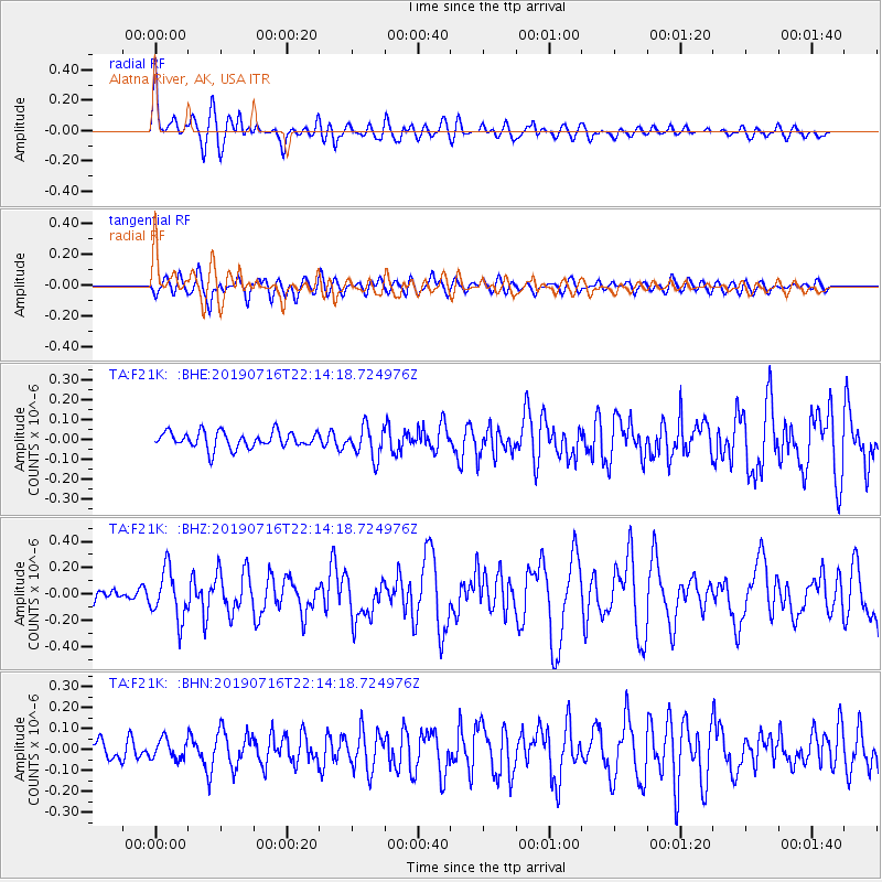
F21K Alatna River, AK, USA - Earthquake Result Viewer
*The percent match for this event was below the threshold and hence no stack was calculated.
| Earthquake location: |
South Of Mariana Islands |
| Earthquake latitude/longitude: |
12.3/144.8 |
| Earthquake time(UTC): |
2019/07/16 (197) 22:03:54 GMT |
| Earthquake Depth: |
34 km |
| Earthquake Magnitude: |
5.7 Mi |
| Earthquake Catalog/Contributor: |
NEIC PDE/pt |
|
| Network: |
TA USArray Transportable Network (new EarthScope stations) |
| Station: |
F21K Alatna River, AK, USA |
| Lat/Lon: |
67.22 N/153.48 W |
| Elevation: |
597 m |
|
| Distance: |
68.0 deg |
| Az: |
21.708 deg |
| Baz: |
248.194 deg |
| Ray Param: |
$rayparam |
*The percent match for this event was below the threshold and hence was not used in the summary stack. |
|
| Radial Match: |
79.28571 % |
| Radial Bump: |
400 |
| Transverse Match: |
64.53201 % |
| Transverse Bump: |
400 |
| SOD ConfigId: |
19053131 |
| Insert Time: |
2019-07-30 22:13:32.740 +0000 |
| GWidth: |
2.5 |
| Max Bumps: |
400 |
| Tol: |
0.001 |
|
Signal To Noise
| Channel | StoN | STA | LTA |
| TA:F21K: :BHZ:20190716T22:14:18.724976Z | 3.4442956 | 1.8423663E-7 | 5.3490364E-8 |
| TA:F21K: :BHN:20190716T22:14:18.724976Z | 1.1249847 | 4.6741995E-8 | 4.1549004E-8 |
| TA:F21K: :BHE:20190716T22:14:18.724976Z | 1.9153507 | 7.7747174E-8 | 4.0591612E-8 |
| Arrivals |
| Ps | |
| PpPs | |
| PsPs/PpSs | |


