You are here: Home > Network List > TA - USArray Transportable Network (new EarthScope stations) Stations List
> Station K29M Barlow Dome, YT, CAN > Earthquake Result Viewer
K29M Barlow Dome, YT, CAN - Earthquake Result Viewer
| Earthquake location: |
South Of Mariana Islands |
| Earthquake latitude/longitude: |
12.3/144.8 |
| Earthquake time(UTC): |
2019/07/16 (197) 22:03:54 GMT |
| Earthquake Depth: |
34 km |
| Earthquake Magnitude: |
5.7 Mi |
| Earthquake Catalog/Contributor: |
NEIC PDE/pt |
|
| Network: |
TA USArray Transportable Network (new EarthScope stations) |
| Station: |
K29M Barlow Dome, YT, CAN |
| Lat/Lon: |
63.84 N/137.52 W |
| Elevation: |
1367 m |
|
| Distance: |
73.6 deg |
| Az: |
26.828 deg |
| Baz: |
264.417 deg |
| Ray Param: |
0.052833077 |
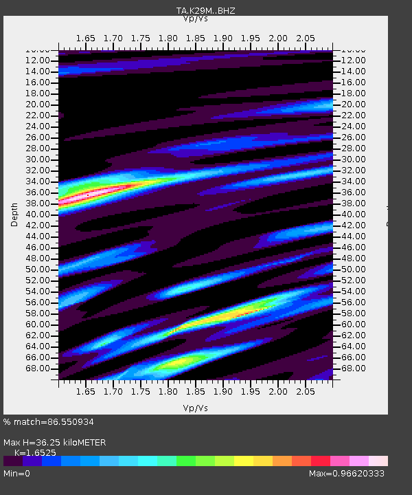
| Estimated Moho Depth: |
36.25 km |
| Estimated Crust Vp/Vs: |
1.65 |
| Assumed Crust Vp: |
6.566 km/s |
| Estimated Crust Vs: |
3.973 km/s |
| Estimated Crust Poisson's Ratio: |
0.21 |
|
| Radial Match: |
86.550934 % |
| Radial Bump: |
400 |
| Transverse Match: |
83.06376 % |
| Transverse Bump: |
400 |
| SOD ConfigId: |
19053131 |
| Insert Time: |
2019-07-30 22:14:16.959 +0000 |
| GWidth: |
2.5 |
| Max Bumps: |
400 |
| Tol: |
0.001 |
|
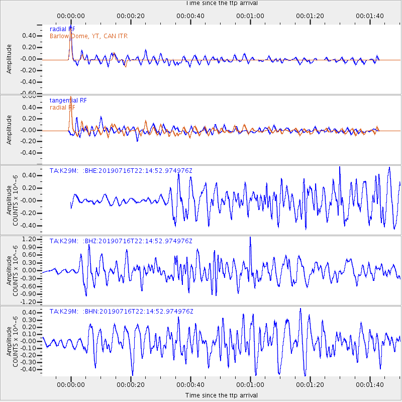
Signal To Noise
| Channel | StoN | STA | LTA |
| TA:K29M: :BHZ:20190716T22:14:52.974976Z | 5.4843063 | 2.9842823E-7 | 5.4414947E-8 |
| TA:K29M: :BHN:20190716T22:14:52.974976Z | 1.0447139 | 5.920122E-8 | 5.6667403E-8 |
| TA:K29M: :BHE:20190716T22:14:52.974976Z | 3.0931582 | 1.3323009E-7 | 4.3072507E-8 |
| Arrivals |
| Ps | 3.7 SECOND |
| PpPs | 14 SECOND |
| PsPs/PpSs | 18 SECOND |


