You are here: Home > Network List > TA - USArray Transportable Network (new EarthScope stations) Stations List
> Station M30M Minto, Yukon, CA > Earthquake Result Viewer
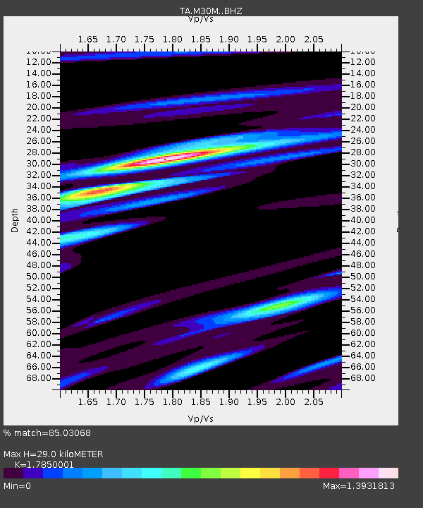
M30M Minto, Yukon, CA - Earthquake Result Viewer
| Earthquake location: |
South Of Mariana Islands |
| Earthquake latitude/longitude: |
12.3/144.8 |
| Earthquake time(UTC): |
2019/07/16 (197) 22:03:54 GMT |
| Earthquake Depth: |
34 km |
| Earthquake Magnitude: |
5.7 Mi |
| Earthquake Catalog/Contributor: |
NEIC PDE/pt |
|
| Network: |
TA USArray Transportable Network (new EarthScope stations) |
| Station: |
M30M Minto, Yukon, CA |
| Lat/Lon: |
62.58 N/136.79 W |
| Elevation: |
782 m |
|
| Distance: |
73.8 deg |
| Az: |
28.178 deg |
| Baz: |
265.443 deg |
| Ray Param: |
0.052688416 |
| Estimated Moho Depth: |
29.0 km |
| Estimated Crust Vp/Vs: |
1.79 |
| Assumed Crust Vp: |
6.566 km/s |
| Estimated Crust Vs: |
3.679 km/s |
| Estimated Crust Poisson's Ratio: |
0.27 |
|
| Radial Match: |
85.03068 % |
| Radial Bump: |
400 |
| Transverse Match: |
68.18818 % |
| Transverse Bump: |
400 |
| SOD ConfigId: |
19053131 |
| Insert Time: |
2019-07-30 22:14:31.297 +0000 |
| GWidth: |
2.5 |
| Max Bumps: |
400 |
| Tol: |
0.001 |
|

Signal To Noise
| Channel | StoN | STA | LTA |
| TA:M30M: :BHZ:20190716T22:14:54.224976Z | 5.3102326 | 2.6788808E-7 | 5.044752E-8 |
| TA:M30M: :BHN:20190716T22:14:54.224976Z | 1.171738 | 6.182053E-8 | 5.275968E-8 |
| TA:M30M: :BHE:20190716T22:14:54.224976Z | 2.2345984 | 1.5305984E-7 | 6.849546E-8 |
| Arrivals |
| Ps | 3.6 SECOND |
| PpPs | 12 SECOND |
| PsPs/PpSs | 15 SECOND |


