You are here: Home > Network List > TA - USArray Transportable Network (new EarthScope stations) Stations List
> Station N15K Kwethluk River, AK, USA > Earthquake Result Viewer
N15K Kwethluk River, AK, USA - Earthquake Result Viewer
| Earthquake location: |
South Of Mariana Islands |
| Earthquake latitude/longitude: |
12.3/144.8 |
| Earthquake time(UTC): |
2019/07/16 (197) 22:03:54 GMT |
| Earthquake Depth: |
34 km |
| Earthquake Magnitude: |
5.7 Mi |
| Earthquake Catalog/Contributor: |
NEIC PDE/pt |
|
| Network: |
TA USArray Transportable Network (new EarthScope stations) |
| Station: |
N15K Kwethluk River, AK, USA |
| Lat/Lon: |
60.17 N/160.09 W |
| Elevation: |
449 m |
|
| Distance: |
62.4 deg |
| Az: |
27.551 deg |
| Baz: |
244.72 deg |
| Ray Param: |
0.060167573 |
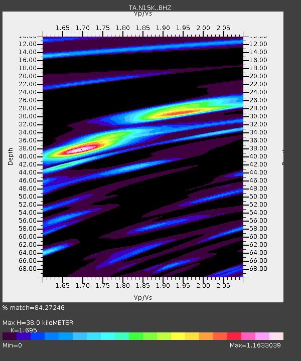
| Estimated Moho Depth: |
38.0 km |
| Estimated Crust Vp/Vs: |
1.70 |
| Assumed Crust Vp: |
6.182 km/s |
| Estimated Crust Vs: |
3.647 km/s |
| Estimated Crust Poisson's Ratio: |
0.23 |
|
| Radial Match: |
84.27246 % |
| Radial Bump: |
400 |
| Transverse Match: |
72.57992 % |
| Transverse Bump: |
400 |
| SOD ConfigId: |
19053131 |
| Insert Time: |
2019-07-30 22:14:33.332 +0000 |
| GWidth: |
2.5 |
| Max Bumps: |
400 |
| Tol: |
0.001 |
|

Signal To Noise
| Channel | StoN | STA | LTA |
| TA:N15K: :BHZ:20190716T22:13:42.950012Z | 4.6531944 | 3.0192749E-7 | 6.4886066E-8 |
| TA:N15K: :BHN:20190716T22:13:42.950012Z | 1.2675396 | 7.5039985E-8 | 5.920129E-8 |
| TA:N15K: :BHE:20190716T22:13:42.950012Z | 1.3090453 | 1.1366771E-7 | 8.683252E-8 |
| Arrivals |
| Ps | 4.5 SECOND |
| PpPs | 16 SECOND |
| PsPs/PpSs | 20 SECOND |


