You are here: Home > Network List > TA - USArray Transportable Network (new EarthScope stations) Stations List
> Station P16K Nushagak River, AK, USA > Earthquake Result Viewer
P16K Nushagak River, AK, USA - Earthquake Result Viewer
| Earthquake location: |
South Of Mariana Islands |
| Earthquake latitude/longitude: |
12.3/144.8 |
| Earthquake time(UTC): |
2019/07/16 (197) 22:03:54 GMT |
| Earthquake Depth: |
34 km |
| Earthquake Magnitude: |
5.7 Mi |
| Earthquake Catalog/Contributor: |
NEIC PDE/pt |
|
| Network: |
TA USArray Transportable Network (new EarthScope stations) |
| Station: |
P16K Nushagak River, AK, USA |
| Lat/Lon: |
59.03 N/157.99 W |
| Elevation: |
86 m |
|
| Distance: |
63.0 deg |
| Az: |
29.213 deg |
| Baz: |
247.292 deg |
| Ray Param: |
0.059835706 |
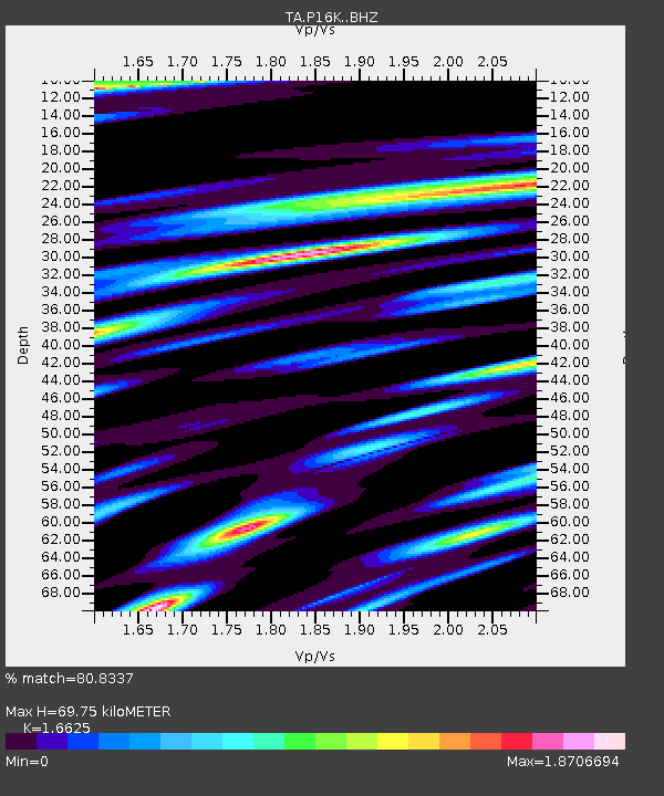
| Estimated Moho Depth: |
69.75 km |
| Estimated Crust Vp/Vs: |
1.66 |
| Assumed Crust Vp: |
6.276 km/s |
| Estimated Crust Vs: |
3.775 km/s |
| Estimated Crust Poisson's Ratio: |
0.22 |
|
| Radial Match: |
80.8337 % |
| Radial Bump: |
400 |
| Transverse Match: |
84.6068 % |
| Transverse Bump: |
372 |
| SOD ConfigId: |
19053131 |
| Insert Time: |
2019-07-30 22:14:45.237 +0000 |
| GWidth: |
2.5 |
| Max Bumps: |
400 |
| Tol: |
0.001 |
|

Signal To Noise
| Channel | StoN | STA | LTA |
| TA:P16K: :BHZ:20190716T22:13:46.375Z | 3.2005827 | 7.567997E-7 | 2.3645684E-7 |
| TA:P16K: :BHN:20190716T22:13:46.375Z | 1.110158 | 3.825199E-7 | 3.445635E-7 |
| TA:P16K: :BHE:20190716T22:13:46.375Z | 1.2634437 | 4.5385E-7 | 3.592166E-7 |
| Arrivals |
| Ps | 7.7 SECOND |
| PpPs | 28 SECOND |
| PsPs/PpSs | 36 SECOND |


