You are here: Home > Network List > TA - USArray Transportable Network (new EarthScope stations) Stations List
> Station I03A Eugene, OR, USA > Earthquake Result Viewer
I03A Eugene, OR, USA - Earthquake Result Viewer
| Earthquake location: |
Kuril Islands |
| Earthquake latitude/longitude: |
46.6/153.3 |
| Earthquake time(UTC): |
2006/11/15 (319) 11:14:13 GMT |
| Earthquake Depth: |
10 km |
| Earthquake Magnitude: |
6.5 MB, 7.8 MS, 8.3 MW, 7.9 MW |
| Earthquake Catalog/Contributor: |
WHDF/NEIC |
|
| Network: |
TA USArray Transportable Network (new EarthScope stations) |
| Station: |
I03A Eugene, OR, USA |
| Lat/Lon: |
43.97 N/123.28 W |
| Elevation: |
206 m |
|
| Distance: |
56.1 deg |
| Az: |
59.795 deg |
| Baz: |
304.363 deg |
| Ray Param: |
0.06436419 |
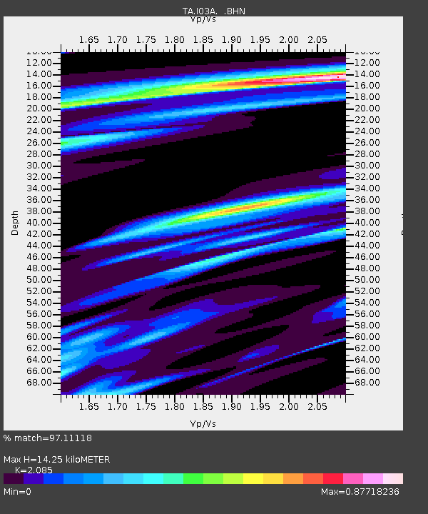
| Estimated Moho Depth: |
14.25 km |
| Estimated Crust Vp/Vs: |
2.09 |
| Assumed Crust Vp: |
6.522 km/s |
| Estimated Crust Vs: |
3.128 km/s |
| Estimated Crust Poisson's Ratio: |
0.35 |
|
| Radial Match: |
97.11118 % |
| Radial Bump: |
292 |
| Transverse Match: |
89.64952 % |
| Transverse Bump: |
400 |
| SOD ConfigId: |
2564 |
| Insert Time: |
2010-03-07 01:57:45.857 +0000 |
| GWidth: |
2.5 |
| Max Bumps: |
400 |
| Tol: |
0.001 |
|

Signal To Noise
| Channel | StoN | STA | LTA |
| TA:I03A: :BHN:20061115T11:23:21.825005Z | 1.1853305 | 8.0491054E-7 | 6.7906E-7 |
| TA:I03A: :BHE:20061115T11:23:21.825005Z | 1.4646244 | 8.732805E-7 | 5.9624875E-7 |
| TA:I03A: :BHZ:20061115T11:23:21.825005Z | 2.5488005 | 1.7085049E-6 | 6.7031726E-7 |
| Arrivals |
| Ps | 2.5 SECOND |
| PpPs | 6.4 SECOND |
| PsPs/PpSs | 8.9 SECOND |


