You are here: Home > Network List > TA - USArray Transportable Network (new EarthScope stations) Stations List
> Station I03A Eugene, OR, USA > Earthquake Result Viewer
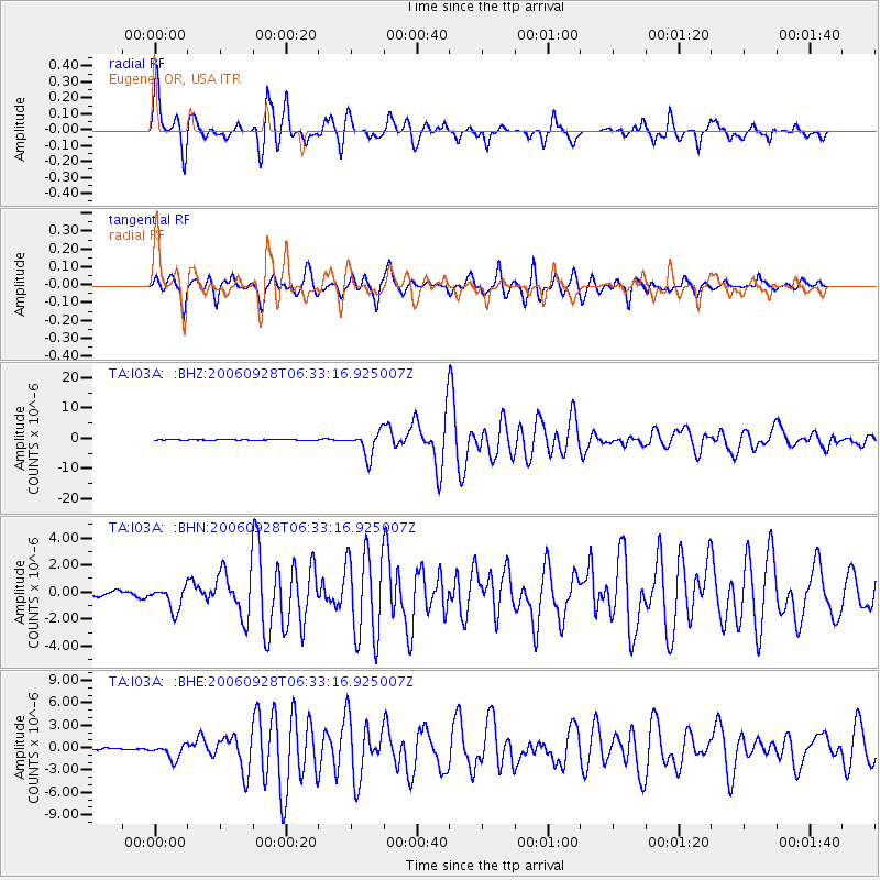
I03A Eugene, OR, USA - Earthquake Result Viewer

| Earthquake location: |
Samoa Islands Region |
| Earthquake latitude/longitude: |
-16.6/-172.0 |
| Earthquake time(UTC): |
2006/09/28 (271) 06:22:09 GMT |
| Earthquake Depth: |
28 km |
| Earthquake Magnitude: |
6.5 MB, 6.6 MS, 6.9 MW, 6.7 MW |
| Earthquake Catalog/Contributor: |
WHDF/NEIC |
|
| Network: |
TA USArray Transportable Network (new EarthScope stations) |
| Station: |
I03A Eugene, OR, USA |
| Lat/Lon: |
43.97 N/123.28 W |
| Elevation: |
206 m |
|
| Distance: |
74.9 deg |
| Az: |
34.209 deg |
| Baz: |
228.303 deg |
| Ray Param: |
0.05196945 |
| Estimated Moho Depth: |
39.75 km |
| Estimated Crust Vp/Vs: |
1.92 |
| Assumed Crust Vp: |
6.522 km/s |
| Estimated Crust Vs: |
3.388 km/s |
| Estimated Crust Poisson's Ratio: |
0.32 |
|
| Radial Match: |
90.35501 % |
| Radial Bump: |
400 |
| Transverse Match: |
90.67955 % |
| Transverse Bump: |
400 |
| SOD ConfigId: |
2665 |
| Insert Time: |
2010-03-07 01:57:56.033 +0000 |
| GWidth: |
2.5 |
| Max Bumps: |
400 |
| Tol: |
0.001 |
|
Signal To Noise
| Channel | StoN | STA | LTA |
| TA:I03A: :BHN:20060928T06:33:16.925007Z | 6.381296 | 8.6262673E-7 | 1.3518049E-7 |
| TA:I03A: :BHE:20060928T06:33:16.925007Z | 8.691267 | 9.955788E-7 | 1.1454932E-7 |
| TA:I03A: :BHZ:20060928T06:33:16.925007Z | 32.869053 | 4.041797E-6 | 1.2296664E-7 |
| Arrivals |
| Ps | 5.8 SECOND |
| PpPs | 17 SECOND |
| PsPs/PpSs | 23 SECOND |


