You are here: Home > Network List > TA - USArray Transportable Network (new EarthScope stations) Stations List
> Station I03A Eugene, OR, USA > Earthquake Result Viewer
I03A Eugene, OR, USA - Earthquake Result Viewer
| Earthquake location: |
Guerrero, Mexico |
| Earthquake latitude/longitude: |
18.6/-101.1 |
| Earthquake time(UTC): |
2006/08/11 (223) 14:30:40 GMT |
| Earthquake Depth: |
60 km |
| Earthquake Magnitude: |
6.0 MB, 6.1 MW, 6.0 MW |
| Earthquake Catalog/Contributor: |
WHDF/NEIC |
|
| Network: |
TA USArray Transportable Network (new EarthScope stations) |
| Station: |
I03A Eugene, OR, USA |
| Lat/Lon: |
43.97 N/123.28 W |
| Elevation: |
206 m |
|
| Distance: |
31.5 deg |
| Az: |
328.465 deg |
| Baz: |
136.591 deg |
| Ray Param: |
0.078931265 |
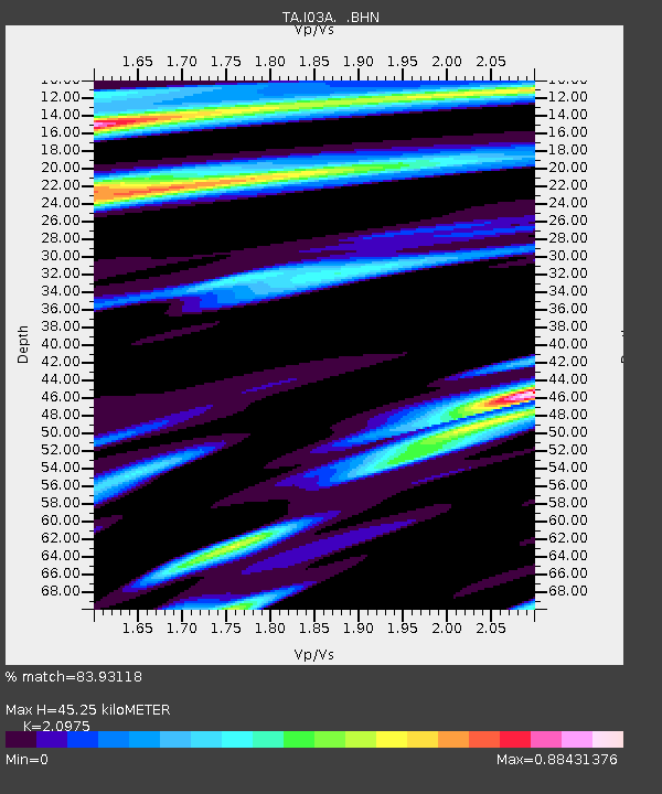
| Estimated Moho Depth: |
45.25 km |
| Estimated Crust Vp/Vs: |
2.10 |
| Assumed Crust Vp: |
6.522 km/s |
| Estimated Crust Vs: |
3.109 km/s |
| Estimated Crust Poisson's Ratio: |
0.35 |
|
| Radial Match: |
83.93118 % |
| Radial Bump: |
400 |
| Transverse Match: |
64.79704 % |
| Transverse Bump: |
400 |
| SOD ConfigId: |
2665 |
| Insert Time: |
2010-03-07 01:58:02.183 +0000 |
| GWidth: |
2.5 |
| Max Bumps: |
400 |
| Tol: |
0.001 |
|

Signal To Noise
| Channel | StoN | STA | LTA |
| TA:I03A: :BHN:20060811T14:36:26.298011Z | 1.3983014 | 4.5204627E-7 | 3.2328242E-7 |
| TA:I03A: :BHE:20060811T14:36:26.298011Z | 2.460498 | 6.835969E-7 | 2.7782866E-7 |
| TA:I03A: :BHZ:20060811T14:36:26.298011Z | 6.3413205 | 1.8032707E-6 | 2.8436833E-7 |
| Arrivals |
| Ps | 8.2 SECOND |
| PpPs | 20 SECOND |
| PsPs/PpSs | 28 SECOND |


