You are here: Home > Network List > UW - Pacific Northwest Regional Seismic Network Stations List
> Station LEBA Lebam, WA, USA > Earthquake Result Viewer
LEBA Lebam, WA, USA - Earthquake Result Viewer
*The percent match for this event was below the threshold and hence no stack was calculated.
| Earthquake location: |
South Of Mariana Islands |
| Earthquake latitude/longitude: |
12.3/144.8 |
| Earthquake time(UTC): |
2019/07/16 (197) 22:03:54 GMT |
| Earthquake Depth: |
34 km |
| Earthquake Magnitude: |
5.7 Mi |
| Earthquake Catalog/Contributor: |
NEIC PDE/pt |
|
| Network: |
UW Pacific Northwest Regional Seismic Network |
| Station: |
LEBA Lebam, WA, USA |
| Lat/Lon: |
46.55 N/123.56 W |
| Elevation: |
73 m |
|
| Distance: |
82.3 deg |
| Az: |
44.122 deg |
| Baz: |
279.646 deg |
| Ray Param: |
$rayparam |
*The percent match for this event was below the threshold and hence was not used in the summary stack. |
|
| Radial Match: |
68.88599 % |
| Radial Bump: |
400 |
| Transverse Match: |
78.65072 % |
| Transverse Bump: |
400 |
| SOD ConfigId: |
19053131 |
| Insert Time: |
2019-07-30 22:16:15.557 +0000 |
| GWidth: |
2.5 |
| Max Bumps: |
400 |
| Tol: |
0.001 |
|
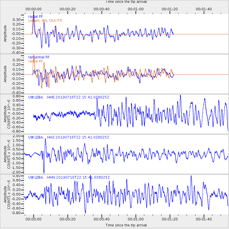
Signal To Noise
| Channel | StoN | STA | LTA |
| UW:LEBA: :HHZ:20190716T22:15:41.038025Z | 1.7297084 | 1.4764935E-7 | 8.5360824E-8 |
| UW:LEBA: :HHN:20190716T22:15:41.038025Z | 1.2729237 | 1.1502781E-7 | 9.036504E-8 |
| UW:LEBA: :HHE:20190716T22:15:41.038025Z | 1.047176 | 1.0248585E-7 | 9.78688E-8 |
| Arrivals |
| Ps | |
| PpPs | |
| PsPs/PpSs | |


