You are here: Home > Network List > TA - USArray Transportable Network (new EarthScope stations) Stations List
> Station I03A Eugene, OR, USA > Earthquake Result Viewer
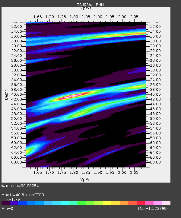
I03A Eugene, OR, USA - Earthquake Result Viewer
| Earthquake location: |
Eastern Siberia, Russia |
| Earthquake latitude/longitude: |
60.9/167.1 |
| Earthquake time(UTC): |
2006/04/20 (110) 23:25:02 GMT |
| Earthquake Depth: |
22 km |
| Earthquake Magnitude: |
6.8 MB, 7.6 MS, 7.6 MW, 7.3 MW |
| Earthquake Catalog/Contributor: |
WHDF/NEIC |
|
| Network: |
TA USArray Transportable Network (new EarthScope stations) |
| Station: |
I03A Eugene, OR, USA |
| Lat/Lon: |
43.97 N/123.28 W |
| Elevation: |
206 m |
|
| Distance: |
43.4 deg |
| Az: |
80.079 deg |
| Baz: |
318.248 deg |
| Ray Param: |
0.07254124 |
| Estimated Moho Depth: |
40.5 km |
| Estimated Crust Vp/Vs: |
1.79 |
| Assumed Crust Vp: |
6.522 km/s |
| Estimated Crust Vs: |
3.643 km/s |
| Estimated Crust Poisson's Ratio: |
0.27 |
|
| Radial Match: |
90.88254 % |
| Radial Bump: |
371 |
| Transverse Match: |
72.68513 % |
| Transverse Bump: |
400 |
| SOD ConfigId: |
2669 |
| Insert Time: |
2010-03-07 01:58:14.945 +0000 |
| GWidth: |
2.5 |
| Max Bumps: |
400 |
| Tol: |
0.001 |
|

Signal To Noise
| Channel | StoN | STA | LTA |
| TA:I03A: :BHN:20060420T23:32:32.275Z | 8.658079 | 4.45745E-6 | 5.148313E-7 |
| TA:I03A: :BHE:20060420T23:32:32.275Z | 6.018949 | 3.1689638E-6 | 5.2649784E-7 |
| TA:I03A: :BHZ:20060420T23:32:32.275Z | 13.489001 | 8.830767E-6 | 6.5466423E-7 |
| Arrivals |
| Ps | 5.2 SECOND |
| PpPs | 16 SECOND |
| PsPs/PpSs | 21 SECOND |


