You are here: Home > Network List > TA - USArray Transportable Network (new EarthScope stations) Stations List
> Station I03A Eugene, OR, USA > Earthquake Result Viewer
I03A Eugene, OR, USA - Earthquake Result Viewer
| Earthquake location: |
Sea Of Japan |
| Earthquake latitude/longitude: |
36.8/134.9 |
| Earthquake time(UTC): |
2007/07/16 (197) 14:17:37 GMT |
| Earthquake Depth: |
350 km |
| Earthquake Magnitude: |
6.2 MB, 6.8 MW, 6.8 MW |
| Earthquake Catalog/Contributor: |
WHDF/NEIC |
|
| Network: |
TA USArray Transportable Network (new EarthScope stations) |
| Station: |
I03A Eugene, OR, USA |
| Lat/Lon: |
43.97 N/123.28 W |
| Elevation: |
206 m |
|
| Distance: |
72.9 deg |
| Az: |
47.656 deg |
| Baz: |
304.755 deg |
| Ray Param: |
0.05230623 |
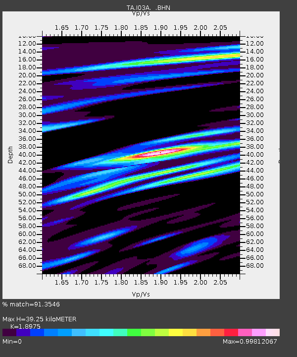
| Estimated Moho Depth: |
39.25 km |
| Estimated Crust Vp/Vs: |
1.90 |
| Assumed Crust Vp: |
6.522 km/s |
| Estimated Crust Vs: |
3.437 km/s |
| Estimated Crust Poisson's Ratio: |
0.31 |
|
| Radial Match: |
91.3546 % |
| Radial Bump: |
400 |
| Transverse Match: |
71.36764 % |
| Transverse Bump: |
400 |
| SOD ConfigId: |
2564 |
| Insert Time: |
2010-03-07 01:58:26.591 +0000 |
| GWidth: |
2.5 |
| Max Bumps: |
400 |
| Tol: |
0.001 |
|
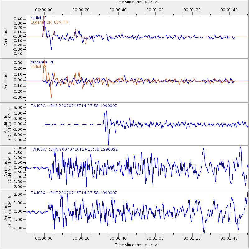
Signal To Noise
| Channel | StoN | STA | LTA |
| TA:I03A: :BHN:20070716T14:27:58.199009Z | 6.449572 | 4.1302E-7 | 6.403835E-8 |
| TA:I03A: :BHE:20070716T14:27:58.199009Z | 4.924944 | 4.4314746E-7 | 8.9980205E-8 |
| TA:I03A: :BHZ:20070716T14:27:58.199009Z | 24.618395 | 3.2067896E-6 | 1.302599E-7 |
| Arrivals |
| Ps | 5.6 SECOND |
| PpPs | 17 SECOND |
| PsPs/PpSs | 22 SECOND |


