You are here: Home > Network List > TA - USArray Transportable Network (new EarthScope stations) Stations List
> Station I03A Eugene, OR, USA > Earthquake Result Viewer
I03A Eugene, OR, USA - Earthquake Result Viewer
| Earthquake location: |
Solomon Islands |
| Earthquake latitude/longitude: |
-8.5/157.0 |
| Earthquake time(UTC): |
2007/04/01 (091) 20:39:56 GMT |
| Earthquake Depth: |
10 km |
| Earthquake Magnitude: |
6.8 MB, 7.9 MS, 8.1 MW, 7.7 ME |
| Earthquake Catalog/Contributor: |
WHDF/NEIC |
|
| Network: |
TA USArray Transportable Network (new EarthScope stations) |
| Station: |
I03A Eugene, OR, USA |
| Lat/Lon: |
43.97 N/123.28 W |
| Elevation: |
206 m |
|
| Distance: |
88.5 deg |
| Az: |
45.281 deg |
| Baz: |
256.806 deg |
| Ray Param: |
0.042569228 |
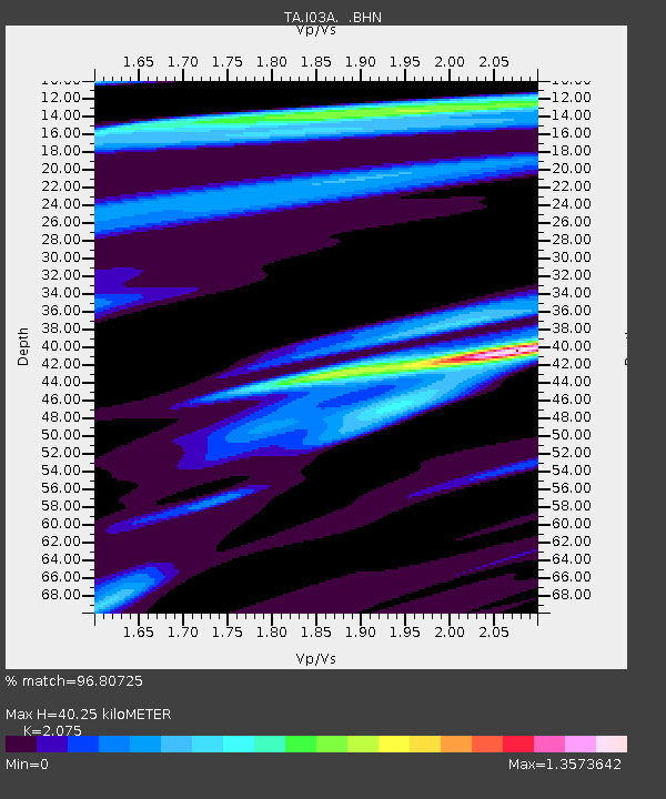
| Estimated Moho Depth: |
40.25 km |
| Estimated Crust Vp/Vs: |
2.08 |
| Assumed Crust Vp: |
6.522 km/s |
| Estimated Crust Vs: |
3.143 km/s |
| Estimated Crust Poisson's Ratio: |
0.35 |
|
| Radial Match: |
96.80725 % |
| Radial Bump: |
356 |
| Transverse Match: |
89.28627 % |
| Transverse Bump: |
400 |
| SOD ConfigId: |
2564 |
| Insert Time: |
2010-03-07 01:58:39.576 +0000 |
| GWidth: |
2.5 |
| Max Bumps: |
400 |
| Tol: |
0.001 |
|

Signal To Noise
| Channel | StoN | STA | LTA |
| TA:I03A: :BHN:20070401T20:52:17.223018Z | 2.2449026 | 5.2170157E-7 | 2.3239387E-7 |
| TA:I03A: :BHE:20070401T20:52:17.223018Z | 2.9140825 | 5.868486E-7 | 2.0138366E-7 |
| TA:I03A: :BHZ:20070401T20:52:17.223018Z | 7.6733193 | 1.7592358E-6 | 2.292666E-7 |
| Arrivals |
| Ps | 6.8 SECOND |
| PpPs | 19 SECOND |
| PsPs/PpSs | 25 SECOND |


