You are here: Home > Network List > TA - USArray Transportable Network (new EarthScope stations) Stations List
> Station C04A Brinnon, WA, USA > Earthquake Result Viewer
C04A Brinnon, WA, USA - Earthquake Result Viewer
| Earthquake location: |
Fiji Islands Region |
| Earthquake latitude/longitude: |
-15.3/-178.6 |
| Earthquake time(UTC): |
2005/12/13 (347) 03:16:06 GMT |
| Earthquake Depth: |
10 km |
| Earthquake Magnitude: |
6.1 MB, 6.8 MS, 6.7 MW, 6.7 MW |
| Earthquake Catalog/Contributor: |
WHDF/NEIC |
|
| Network: |
TA USArray Transportable Network (new EarthScope stations) |
| Station: |
C04A Brinnon, WA, USA |
| Lat/Lon: |
47.72 N/122.97 W |
| Elevation: |
53 m |
|
| Distance: |
79.9 deg |
| Az: |
34.466 deg |
| Baz: |
233.987 deg |
| Ray Param: |
0.048639115 |
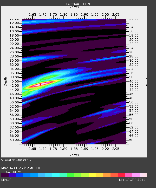
| Estimated Moho Depth: |
41.25 km |
| Estimated Crust Vp/Vs: |
1.69 |
| Assumed Crust Vp: |
6.566 km/s |
| Estimated Crust Vs: |
3.891 km/s |
| Estimated Crust Poisson's Ratio: |
0.23 |
|
| Radial Match: |
90.08576 % |
| Radial Bump: |
321 |
| Transverse Match: |
85.61731 % |
| Transverse Bump: |
333 |
| SOD ConfigId: |
2564 |
| Insert Time: |
2010-03-07 01:58:49.031 +0000 |
| GWidth: |
2.5 |
| Max Bumps: |
400 |
| Tol: |
0.001 |
|

Signal To Noise
| Channel | StoN | STA | LTA |
| TA:C04A: :BHN:20051213T03:27:43.90002Z | 0.8870786 | 2.2046223E-7 | 2.4852616E-7 |
| TA:C04A: :BHE:20051213T03:27:43.90002Z | 1.1349347 | 1.4577444E-7 | 1.2844303E-7 |
| TA:C04A: :BHZ:20051213T03:27:43.90002Z | 4.294015 | 8.2407644E-7 | 1.9191279E-7 |
| Arrivals |
| Ps | 4.5 SECOND |
| PpPs | 16 SECOND |
| PsPs/PpSs | 21 SECOND |


