You are here: Home > Network List > TA - USArray Transportable Network (new EarthScope stations) Stations List
> Station C04A Brinnon, WA, USA > Earthquake Result Viewer
C04A Brinnon, WA, USA - Earthquake Result Viewer
| Earthquake location: |
Vanuatu Islands |
| Earthquake latitude/longitude: |
-15.4/168.6 |
| Earthquake time(UTC): |
2007/07/15 (196) 09:27:34 GMT |
| Earthquake Depth: |
8.0 km |
| Earthquake Magnitude: |
6.0 MB, 5.8 MS, 6.1 MW, 6.0 MW |
| Earthquake Catalog/Contributor: |
WHDF/NEIC |
|
| Network: |
TA USArray Transportable Network (new EarthScope stations) |
| Station: |
C04A Brinnon, WA, USA |
| Lat/Lon: |
47.72 N/122.97 W |
| Elevation: |
53 m |
|
| Distance: |
87.4 deg |
| Az: |
38.948 deg |
| Baz: |
243.895 deg |
| Ray Param: |
0.04334153 |
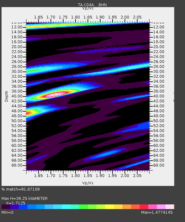
| Estimated Moho Depth: |
39.25 km |
| Estimated Crust Vp/Vs: |
1.71 |
| Assumed Crust Vp: |
6.566 km/s |
| Estimated Crust Vs: |
3.834 km/s |
| Estimated Crust Poisson's Ratio: |
0.24 |
|
| Radial Match: |
91.87189 % |
| Radial Bump: |
400 |
| Transverse Match: |
92.43248 % |
| Transverse Bump: |
400 |
| SOD ConfigId: |
2564 |
| Insert Time: |
2010-03-07 01:59:34.467 +0000 |
| GWidth: |
2.5 |
| Max Bumps: |
400 |
| Tol: |
0.001 |
|
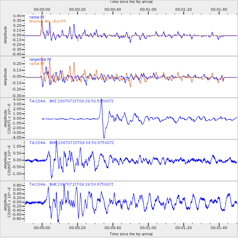
Signal To Noise
| Channel | StoN | STA | LTA |
| TA:C04A: :BHN:20070715T09:39:50.675007Z | 6.488557 | 2.6187584E-7 | 4.0359645E-8 |
| TA:C04A: :BHE:20070715T09:39:50.675007Z | 6.055976 | 2.7278477E-7 | 4.50439E-8 |
| TA:C04A: :BHZ:20070715T09:39:50.675007Z | 34.201935 | 1.6449834E-6 | 4.8096208E-8 |
| Arrivals |
| Ps | 4.4 SECOND |
| PpPs | 16 SECOND |
| PsPs/PpSs | 20 SECOND |


