C04A Brinnon, WA, USA - Earthquake Result Viewer
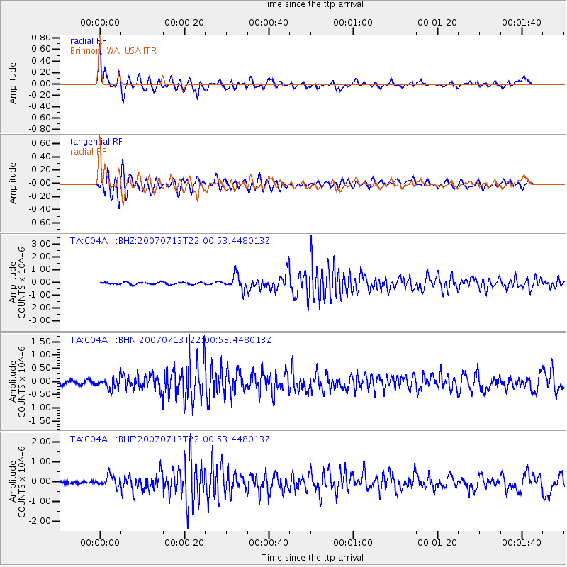
Earthquake location: Andreanof Islands, Aleutian Is.
Earthquake latitude/longitude: 51.8/-176.3
Earthquake time(UTC): 2007/07/13 (194) 21:54:43 GMT
Earthquake Depth: 35 km
Earthquake Magnitude: 5.7 MB, 5.6 MS, 6.0 MW, 5.9 MW
Earthquake Catalog/Contributor: WHDF/NEIC
Network: TA USArray Transportable Network (new EarthScope stations)
Station: C04A Brinnon, WA, USA
Lat/Lon: 47.72 N/122.97 W
Elevation: 53 m
Distance: 34.0 deg
Az: 75.383 deg
Baz: 297.24 deg
Ray Param: 0.07787869
Estimated Moho Depth: 12.25 km
Estimated Crust Vp/Vs: 1.61
Assumed Crust Vp: 6.566 km/s
Estimated Crust Vs: 4.091 km/s
Estimated Crust Poisson's Ratio: 0.18
Radial Match: 84.70499 %
Radial Bump: 400
Transverse Match: 82.14838 %
Transverse Bump: 400
SOD ConfigId: 2564
Insert Time: 2010-03-07 01:59:36.791 +0000
GWidth: 2.5
Max Bumps: 400
Tol: 0.001

Signal To Noise

ChannelStoNSTALTA
TA:C04A: :BHN:20070713T22:00:53.448013Z3.3073182.0685893E-76.254582E-8
TA:C04A: :BHE:20070713T22:00:53.448013Z5.2577882.801421E-75.3281358E-8
TA:C04A: :BHZ:20070713T22:00:53.448013Z7.2807515.733026E-77.874223E-8
Arrivals
Ps1.2 SECOND
PpPs4.4 SECOND
PsPs/PpSs5.7 SECOND