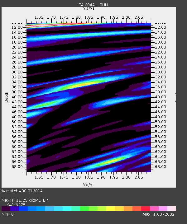
C04A Brinnon, WA, USA - Earthquake Result Viewer
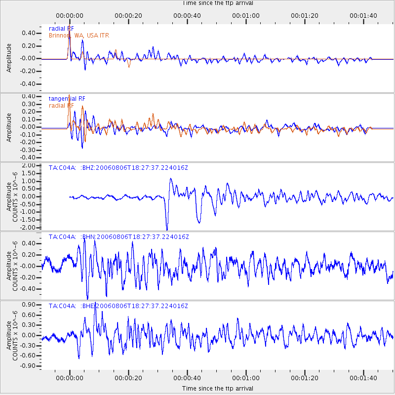
Earthquake location: Bonin Islands, Japan Region
Earthquake latitude/longitude: 26.1/144.0
Earthquake time(UTC): 2006/08/06 (218) 18:16:40 GMT
Earthquake Depth: 23 km
Earthquake Magnitude: 6.0 MB, 5.6 MS, 5.8 MW, 5.8 MW
Earthquake Catalog/Contributor: WHDF/NEIC
Network: TA USArray Transportable Network (new EarthScope stations)
Station: C04A Brinnon, WA, USA
Lat/Lon: 47.72 N/122.97 W
Elevation: 53 m
Distance: 73.1 deg
Az: 44.815 deg
Baz: 290.217 deg
Ray Param: 0.053211052
Estimated Moho Depth: 11.25 km
Estimated Crust Vp/Vs: 1.63
Assumed Crust Vp: 6.566 km/s
Estimated Crust Vs: 4.035 km/s
Estimated Crust Poisson's Ratio: 0.20
Radial Match: 80.016014 %
Radial Bump: 400
Transverse Match: 74.335495 %
Transverse Bump: 400
SOD ConfigId: 5423
Insert Time: 2010-03-07 01:59:51.794 +0000
GWidth: 2.5
Max Bumps: 400
Tol: 0.001

Signal To Noise

ChannelStoNSTALTA
TA:C04A: :BHN:20060806T18:27:37.224016Z2.04349542.0829312E-71.0192982E-7
TA:C04A: :BHE:20060806T18:27:37.224016Z3.52951222.1421809E-76.06934E-8
TA:C04A: :BHZ:20060806T18:27:37.224016Z10.8950378.3722705E-77.6844806E-8
Arrivals
Ps1.1 SECOND
PpPs4.3 SECOND
PsPs/PpSs5.4 SECOND