You are here: Home > Network List > TA - USArray Transportable Network (new EarthScope stations) Stations List
> Station C04A Brinnon, WA, USA > Earthquake Result Viewer
C04A Brinnon, WA, USA - Earthquake Result Viewer
| Earthquake location: |
Southern Peru |
| Earthquake latitude/longitude: |
-15.6/-73.2 |
| Earthquake time(UTC): |
2006/09/30 (273) 16:26:56 GMT |
| Earthquake Depth: |
107 km |
| Earthquake Magnitude: |
5.6 MB, 6.0 MW, 5.9 MW |
| Earthquake Catalog/Contributor: |
WHDF/NEIC |
|
| Network: |
TA USArray Transportable Network (new EarthScope stations) |
| Station: |
C04A Brinnon, WA, USA |
| Lat/Lon: |
47.72 N/122.97 W |
| Elevation: |
53 m |
|
| Distance: |
77.1 deg |
| Az: |
328.05 deg |
| Baz: |
130.957 deg |
| Ray Param: |
0.050290924 |
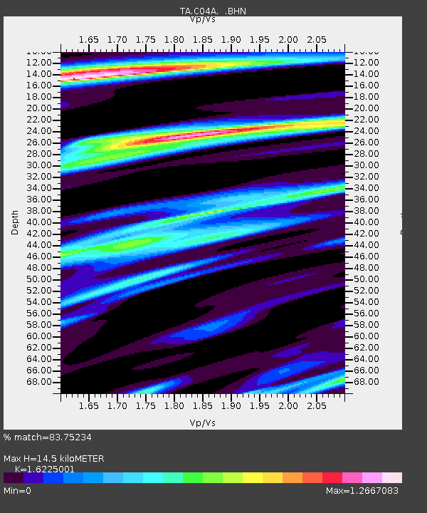
| Estimated Moho Depth: |
14.5 km |
| Estimated Crust Vp/Vs: |
1.62 |
| Assumed Crust Vp: |
6.566 km/s |
| Estimated Crust Vs: |
4.047 km/s |
| Estimated Crust Poisson's Ratio: |
0.19 |
|
| Radial Match: |
83.75234 % |
| Radial Bump: |
400 |
| Transverse Match: |
63.2077 % |
| Transverse Bump: |
400 |
| SOD ConfigId: |
2564 |
| Insert Time: |
2010-03-07 02:00:18.587 +0000 |
| GWidth: |
2.5 |
| Max Bumps: |
400 |
| Tol: |
0.001 |
|
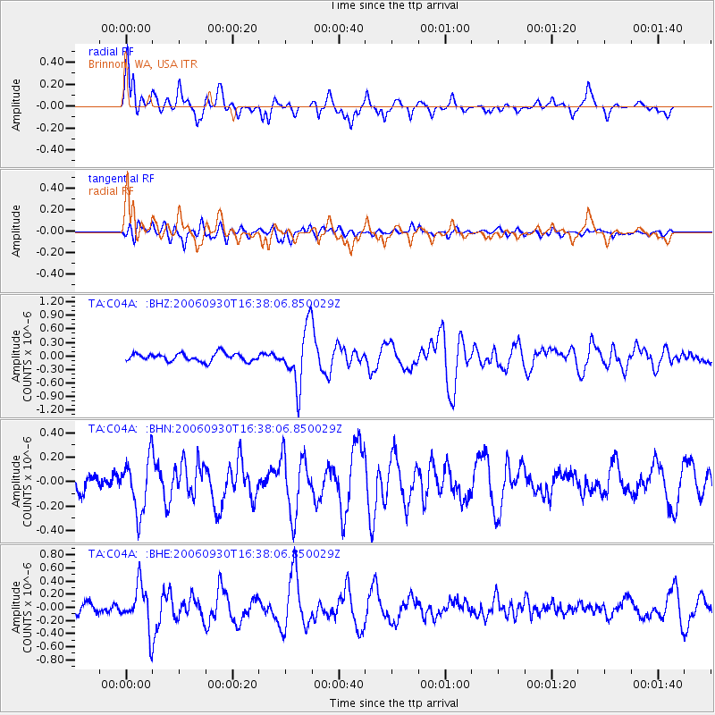
Signal To Noise
| Channel | StoN | STA | LTA |
| TA:C04A: :BHN:20060930T16:38:06.850029Z | 3.1619294 | 2.2123487E-7 | 6.9968316E-8 |
| TA:C04A: :BHE:20060930T16:38:06.850029Z | 4.161693 | 3.3039115E-7 | 7.938864E-8 |
| TA:C04A: :BHZ:20060930T16:38:06.850029Z | 7.2466974 | 6.364803E-7 | 8.7830394E-8 |
| Arrivals |
| Ps | 1.4 SECOND |
| PpPs | 5.6 SECOND |
| PsPs/PpSs | 7.0 SECOND |


