You are here: Home > Network List > TA - USArray Transportable Network (new EarthScope stations) Stations List
> Station C04A Brinnon, WA, USA > Earthquake Result Viewer
C04A Brinnon, WA, USA - Earthquake Result Viewer

| Earthquake location: |
Vanuatu Islands |
| Earthquake latitude/longitude: |
-18.9/169.0 |
| Earthquake time(UTC): |
2006/10/03 (276) 18:03:14 GMT |
| Earthquake Depth: |
171 km |
| Earthquake Magnitude: |
5.9 MB, 6.3 MW, 6.3 MW |
| Earthquake Catalog/Contributor: |
WHDF/NEIC |
|
| Network: |
TA USArray Transportable Network (new EarthScope stations) |
| Station: |
C04A Brinnon, WA, USA |
| Lat/Lon: |
47.72 N/122.97 W |
| Elevation: |
53 m |
|
| Distance: |
89.9 deg |
| Az: |
38.771 deg |
| Baz: |
241.417 deg |
| Ray Param: |
0.041676745 |
| Estimated Moho Depth: |
11.25 km |
| Estimated Crust Vp/Vs: |
1.60 |
| Assumed Crust Vp: |
6.566 km/s |
| Estimated Crust Vs: |
4.104 km/s |
| Estimated Crust Poisson's Ratio: |
0.18 |
|
| Radial Match: |
83.52659 % |
| Radial Bump: |
400 |
| Transverse Match: |
82.034386 % |
| Transverse Bump: |
400 |
| SOD ConfigId: |
2665 |
| Insert Time: |
2010-03-07 02:00:22.826 +0000 |
| GWidth: |
2.5 |
| Max Bumps: |
400 |
| Tol: |
0.001 |
|
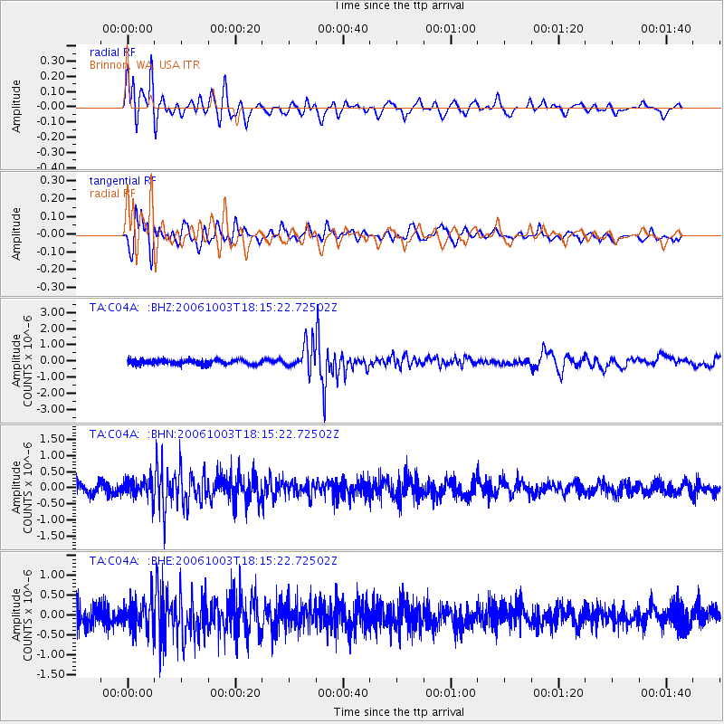
Signal To Noise
| Channel | StoN | STA | LTA |
| TA:C04A: :BHN:20061003T18:15:22.72502Z | 1.3399153 | 2.8056033E-7 | 2.093866E-7 |
| TA:C04A: :BHE:20061003T18:15:22.72502Z | 0.8341123 | 3.7447825E-7 | 4.4895424E-7 |
| TA:C04A: :BHZ:20061003T18:15:22.72502Z | 5.692811 | 8.1419415E-7 | 1.4302145E-7 |
| Arrivals |
| Ps | 1.1 SECOND |
| PpPs | 4.3 SECOND |
| PsPs/PpSs | 5.4 SECOND |


