You are here: Home > Network List > TA - USArray Transportable Network (new EarthScope stations) Stations List
> Station C04A Brinnon, WA, USA > Earthquake Result Viewer
C04A Brinnon, WA, USA - Earthquake Result Viewer
| Earthquake location: |
Kuril Islands |
| Earthquake latitude/longitude: |
46.5/153.2 |
| Earthquake time(UTC): |
2006/10/01 (274) 09:06:02 GMT |
| Earthquake Depth: |
19 km |
| Earthquake Magnitude: |
6.1 MB, 6.4 MS, 6.6 MW, 6.5 MW |
| Earthquake Catalog/Contributor: |
WHDF/NEIC |
|
| Network: |
TA USArray Transportable Network (new EarthScope stations) |
| Station: |
C04A Brinnon, WA, USA |
| Lat/Lon: |
47.72 N/122.97 W |
| Elevation: |
53 m |
|
| Distance: |
54.3 deg |
| Az: |
55.755 deg |
| Baz: |
302.209 deg |
| Ray Param: |
0.065513566 |
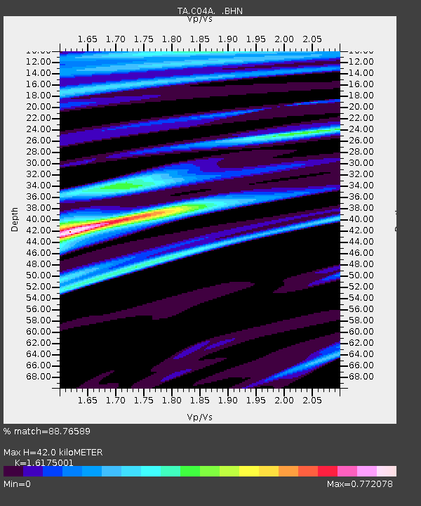
| Estimated Moho Depth: |
42.0 km |
| Estimated Crust Vp/Vs: |
1.62 |
| Assumed Crust Vp: |
6.566 km/s |
| Estimated Crust Vs: |
4.059 km/s |
| Estimated Crust Poisson's Ratio: |
0.19 |
|
| Radial Match: |
88.76589 % |
| Radial Bump: |
292 |
| Transverse Match: |
72.69027 % |
| Transverse Bump: |
400 |
| SOD ConfigId: |
2665 |
| Insert Time: |
2010-03-07 02:00:24.613 +0000 |
| GWidth: |
2.5 |
| Max Bumps: |
400 |
| Tol: |
0.001 |
|

Signal To Noise
| Channel | StoN | STA | LTA |
| TA:C04A: :BHN:20061001T09:14:56.299004Z | 0.85135955 | 1.4585252E-7 | 1.7131718E-7 |
| TA:C04A: :BHE:20061001T09:14:56.299004Z | 2.400825 | 2.134119E-7 | 8.889107E-8 |
| TA:C04A: :BHZ:20061001T09:14:56.299004Z | 1.7783986 | 4.3150763E-7 | 2.426383E-7 |
| Arrivals |
| Ps | 4.2 SECOND |
| PpPs | 16 SECOND |
| PsPs/PpSs | 20 SECOND |


