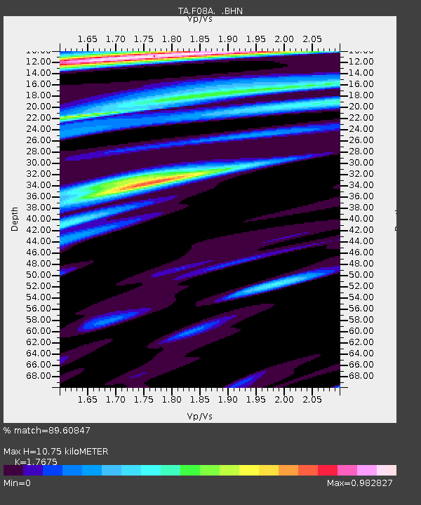
F08A Pendleton, OR, USA - Earthquake Result Viewer
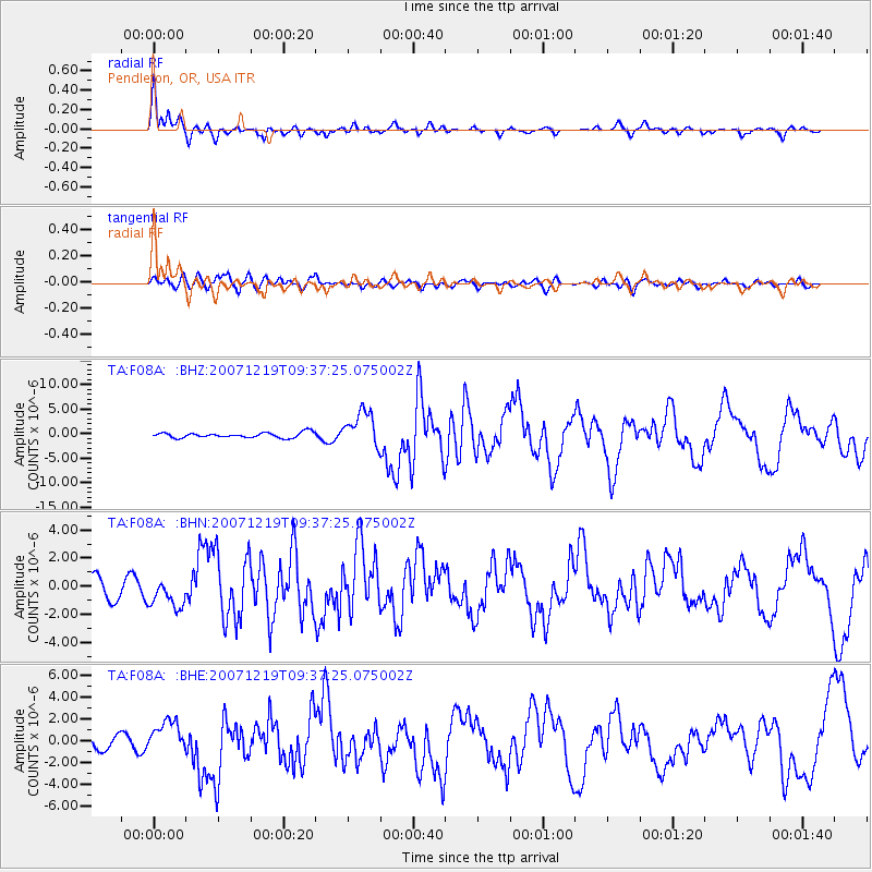
Earthquake location: Andreanof Islands, Aleutian Is.
Earthquake latitude/longitude: 51.4/-179.5
Earthquake time(UTC): 2007/12/19 (353) 09:30:27 GMT
Earthquake Depth: 29 km
Earthquake Magnitude: 6.4 MB, 7.1 MS, 7.1 MW, 7.0 MW
Earthquake Catalog/Contributor: WHDF/NEIC
Network: TA USArray Transportable Network (new EarthScope stations)
Station: F08A Pendleton, OR, USA
Lat/Lon: 45.80 N/118.78 W
Elevation: 487 m
Distance: 39.6 deg
Az: 73.43 deg
Baz: 300.804 deg
Ray Param: 0.074864045
Estimated Moho Depth: 10.75 km
Estimated Crust Vp/Vs: 1.77
Assumed Crust Vp: 6.571 km/s
Estimated Crust Vs: 3.718 km/s
Estimated Crust Poisson's Ratio: 0.26
Radial Match: 89.60847 %
Radial Bump: 400
Transverse Match: 69.73505 %
Transverse Bump: 400
SOD ConfigId: 2564
Insert Time: 2010-03-07 02:00:39.820 +0000
GWidth: 2.5
Max Bumps: 400
Tol: 0.001

Signal To Noise

ChannelStoNSTALTA
TA:F08A: :BHN:20071219T09:37:25.075002Z1.6495291.0355494E-66.2778486E-7
TA:F08A: :BHE:20071219T09:37:25.075002Z2.50526831.461841E-65.8350673E-7
TA:F08A: :BHZ:20071219T09:37:25.075002Z6.873363.600549E-65.2384115E-7
Arrivals
Ps1.4 SECOND
PpPs4.2 SECOND
PsPs/PpSs5.6 SECOND