You are here: Home > Network List > TA - USArray Transportable Network (new EarthScope stations) Stations List
> Station F08A Pendleton, OR, USA > Earthquake Result Viewer
F08A Pendleton, OR, USA - Earthquake Result Viewer
| Earthquake location: |
South Of Fiji Islands |
| Earthquake latitude/longitude: |
-26.0/-177.5 |
| Earthquake time(UTC): |
2007/12/09 (343) 07:28:20 GMT |
| Earthquake Depth: |
152 km |
| Earthquake Magnitude: |
7.0 MB, 7.8 MW, 7.7 MW |
| Earthquake Catalog/Contributor: |
WHDF/NEIC |
|
| Network: |
TA USArray Transportable Network (new EarthScope stations) |
| Station: |
F08A Pendleton, OR, USA |
| Lat/Lon: |
45.80 N/118.78 W |
| Elevation: |
487 m |
|
| Distance: |
89.1 deg |
| Az: |
36.733 deg |
| Baz: |
230.299 deg |
| Ray Param: |
0.041749574 |
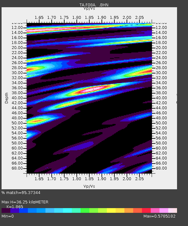
| Estimated Moho Depth: |
36.25 km |
| Estimated Crust Vp/Vs: |
1.87 |
| Assumed Crust Vp: |
6.571 km/s |
| Estimated Crust Vs: |
3.523 km/s |
| Estimated Crust Poisson's Ratio: |
0.30 |
|
| Radial Match: |
95.37344 % |
| Radial Bump: |
400 |
| Transverse Match: |
85.94146 % |
| Transverse Bump: |
400 |
| SOD ConfigId: |
2564 |
| Insert Time: |
2010-03-07 02:00:41.621 +0000 |
| GWidth: |
2.5 |
| Max Bumps: |
400 |
| Tol: |
0.001 |
|
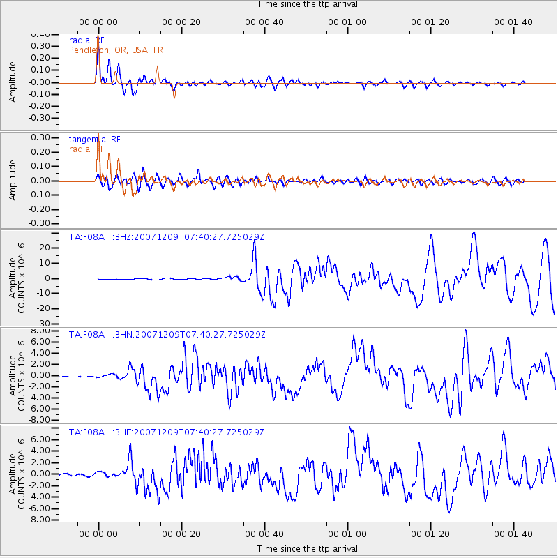
Signal To Noise
| Channel | StoN | STA | LTA |
| TA:F08A: :BHN:20071209T07:40:27.725029Z | 1.9873048 | 3.2173241E-7 | 1.6189384E-7 |
| TA:F08A: :BHE:20071209T07:40:27.725029Z | 1.9767374 | 4.16361E-7 | 2.1063042E-7 |
| TA:F08A: :BHZ:20071209T07:40:27.725029Z | 3.9064786 | 1.2512554E-6 | 3.2030263E-7 |
| Arrivals |
| Ps | 4.9 SECOND |
| PpPs | 15 SECOND |
| PsPs/PpSs | 20 SECOND |


