You are here: Home > Network List > TA - USArray Transportable Network (new EarthScope stations) Stations List
> Station F08A Pendleton, OR, USA > Earthquake Result Viewer
F08A Pendleton, OR, USA - Earthquake Result Viewer
| Earthquake location: |
Mariana Islands |
| Earthquake latitude/longitude: |
18.9/145.4 |
| Earthquake time(UTC): |
2007/10/31 (304) 03:30:17 GMT |
| Earthquake Depth: |
223 km |
| Earthquake Magnitude: |
6.2 MB, 7.2 MW, 7.2 MW |
| Earthquake Catalog/Contributor: |
WHDF/NEIC |
|
| Network: |
TA USArray Transportable Network (new EarthScope stations) |
| Station: |
F08A Pendleton, OR, USA |
| Lat/Lon: |
45.80 N/118.78 W |
| Elevation: |
487 m |
|
| Distance: |
80.7 deg |
| Az: |
44.855 deg |
| Baz: |
287.352 deg |
| Ray Param: |
0.047566187 |
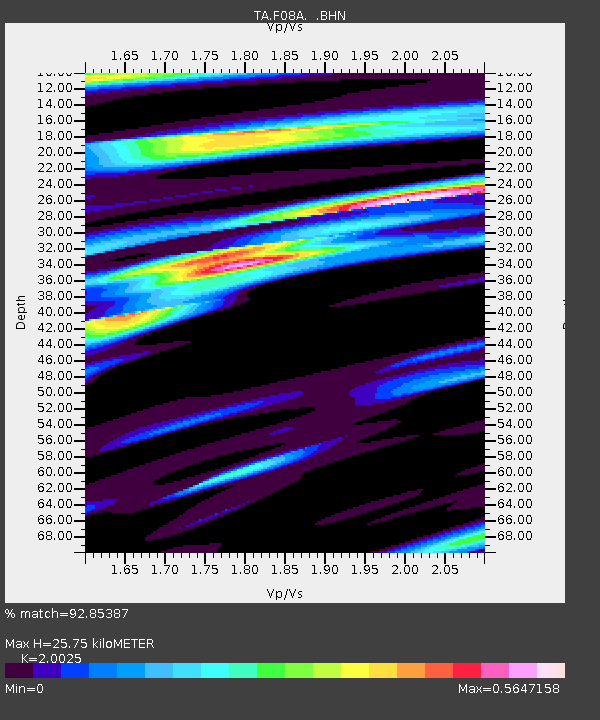
| Estimated Moho Depth: |
25.75 km |
| Estimated Crust Vp/Vs: |
2.00 |
| Assumed Crust Vp: |
6.571 km/s |
| Estimated Crust Vs: |
3.281 km/s |
| Estimated Crust Poisson's Ratio: |
0.33 |
|
| Radial Match: |
92.85387 % |
| Radial Bump: |
400 |
| Transverse Match: |
80.47333 % |
| Transverse Bump: |
400 |
| SOD ConfigId: |
2564 |
| Insert Time: |
2010-03-07 02:00:50.719 +0000 |
| GWidth: |
2.5 |
| Max Bumps: |
400 |
| Tol: |
0.001 |
|
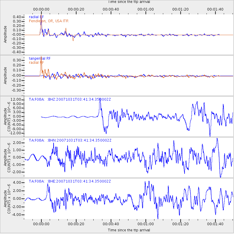
Signal To Noise
| Channel | StoN | STA | LTA |
| TA:F08A: :BHN:20071031T03:41:34.350002Z | 2.5782554 | 4.9471396E-7 | 1.9187935E-7 |
| TA:F08A: :BHE:20071031T03:41:34.350002Z | 7.0571256 | 1.4849633E-6 | 2.1042041E-7 |
| TA:F08A: :BHZ:20071031T03:41:34.350002Z | 12.541747 | 4.869194E-6 | 3.882389E-7 |
| Arrivals |
| Ps | 4.0 SECOND |
| PpPs | 11 SECOND |
| PsPs/PpSs | 16 SECOND |


