You are here: Home > Network List > IU - Global Seismograph Network (GSN - IRIS/USGS) Stations List
> Station RSSD Black Hills, South Dakota, USA > Earthquake Result Viewer
RSSD Black Hills, South Dakota, USA - Earthquake Result Viewer
*The percent match for this event was below the threshold and hence no stack was calculated.
| Earthquake location: |
Peru-Brazil Border Region |
| Earthquake latitude/longitude: |
-10.0/-71.0 |
| Earthquake time(UTC): |
2016/12/18 (353) 13:30:11 GMT |
| Earthquake Depth: |
619 km |
| Earthquake Magnitude: |
6.4 Mww |
| Earthquake Catalog/Contributor: |
NEIC PDE/us |
|
| Network: |
IU Global Seismograph Network (GSN - IRIS/USGS) |
| Station: |
RSSD Black Hills, South Dakota, USA |
| Lat/Lon: |
44.12 N/104.04 W |
| Elevation: |
2090 m |
|
| Distance: |
61.6 deg |
| Az: |
333.472 deg |
| Baz: |
142.344 deg |
| Ray Param: |
$rayparam |
*The percent match for this event was below the threshold and hence was not used in the summary stack. |
|
| Radial Match: |
70.56967 % |
| Radial Bump: |
400 |
| Transverse Match: |
77.95653 % |
| Transverse Bump: |
400 |
| SOD ConfigId: |
1894071 |
| Insert Time: |
2017-01-01 13:32:37.579 +0000 |
| GWidth: |
2.5 |
| Max Bumps: |
400 |
| Tol: |
0.001 |
|
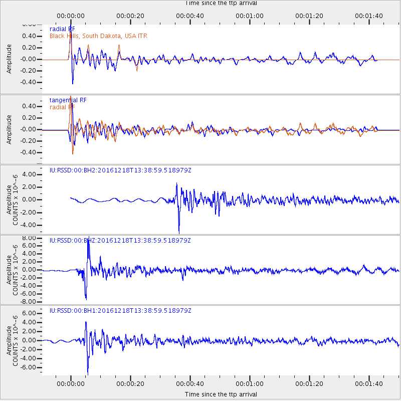
Signal To Noise
| Channel | StoN | STA | LTA |
| IU:RSSD:00:BHZ:20161218T13:38:59.518979Z | 4.3219137 | 1.05296E-6 | 2.436328E-7 |
| IU:RSSD:00:BH1:20161218T13:38:59.518979Z | 1.0011258 | 4.330393E-7 | 4.3255233E-7 |
| IU:RSSD:00:BH2:20161218T13:38:59.518979Z | 1.3068086 | 2.6040956E-7 | 1.992714E-7 |
| Arrivals |
| Ps | |
| PpPs | |
| PsPs/PpSs | |


