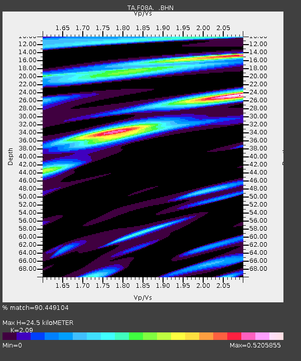
F08A Pendleton, OR, USA - Earthquake Result Viewer
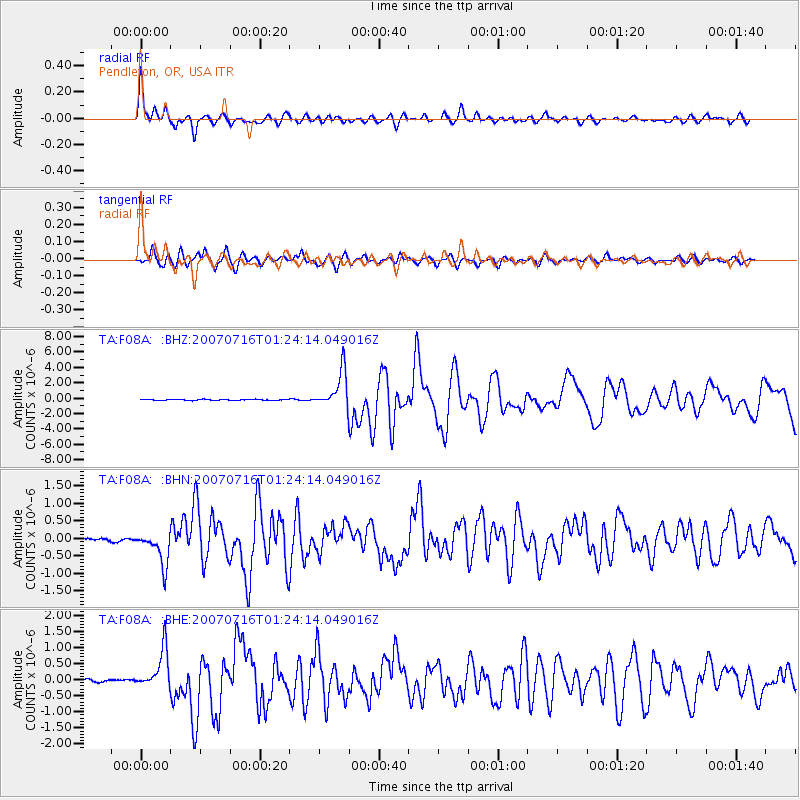
Earthquake location: Near West Coast Of Honshu, Japan
Earthquake latitude/longitude: 37.5/138.4
Earthquake time(UTC): 2007/07/16 (197) 01:13:22 GMT
Earthquake Depth: 12 km
Earthquake Magnitude: 6.5 MB, 6.4 MS, 6.6 MW, 6.5 MW
Earthquake Catalog/Contributor: WHDF/NEIC
Network: TA USArray Transportable Network (new EarthScope stations)
Station: F08A Pendleton, OR, USA
Lat/Lon: 45.80 N/118.78 W
Elevation: 487 m
Distance: 71.9 deg
Az: 45.869 deg
Baz: 305.356 deg
Ray Param: 0.054007854
Estimated Moho Depth: 24.5 km
Estimated Crust Vp/Vs: 2.09
Assumed Crust Vp: 6.571 km/s
Estimated Crust Vs: 3.144 km/s
Estimated Crust Poisson's Ratio: 0.35
Radial Match: 90.449104 %
Radial Bump: 400
Transverse Match: 82.516884 %
Transverse Bump: 400
SOD ConfigId: 2564
Insert Time: 2010-03-07 02:01:11.945 +0000
GWidth: 2.5
Max Bumps: 400
Tol: 0.001

Signal To Noise

ChannelStoNSTALTA
TA:F08A: :BHN:20070716T01:24:14.049016Z9.8196184.868247E-74.9576748E-8
TA:F08A: :BHE:20070716T01:24:14.049016Z15.294696.103764E-73.990773E-8
TA:F08A: :BHZ:20070716T01:24:14.049016Z35.7937972.3862606E-66.666688E-8
Arrivals
Ps4.2 SECOND
PpPs11 SECOND
PsPs/PpSs15 SECOND