You are here: Home > Network List > IW - Intermountain West Stations List
> Station MOOW Moose Ponds, Wyoming, USA > Earthquake Result Viewer
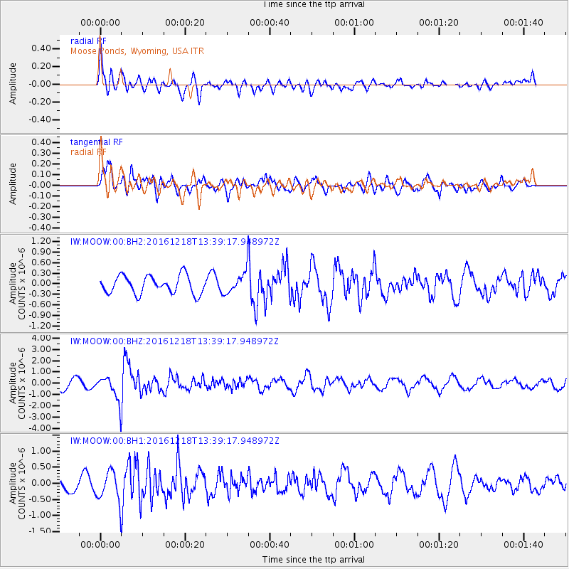
MOOW Moose Ponds, Wyoming, USA - Earthquake Result Viewer
*The percent match for this event was below the threshold and hence no stack was calculated.
| Earthquake location: |
Peru-Brazil Border Region |
| Earthquake latitude/longitude: |
-10.0/-71.0 |
| Earthquake time(UTC): |
2016/12/18 (353) 13:30:11 GMT |
| Earthquake Depth: |
619 km |
| Earthquake Magnitude: |
6.4 Mww |
| Earthquake Catalog/Contributor: |
NEIC PDE/us |
|
| Network: |
IW Intermountain West |
| Station: |
MOOW Moose Ponds, Wyoming, USA |
| Lat/Lon: |
43.75 N/110.74 W |
| Elevation: |
2128 m |
|
| Distance: |
64.5 deg |
| Az: |
329.095 deg |
| Baz: |
135.719 deg |
| Ray Param: |
$rayparam |
*The percent match for this event was below the threshold and hence was not used in the summary stack. |
|
| Radial Match: |
62.665817 % |
| Radial Bump: |
400 |
| Transverse Match: |
66.34826 % |
| Transverse Bump: |
400 |
| SOD ConfigId: |
1894071 |
| Insert Time: |
2017-01-01 13:32:53.212 +0000 |
| GWidth: |
2.5 |
| Max Bumps: |
400 |
| Tol: |
0.001 |
|
Signal To Noise
| Channel | StoN | STA | LTA |
| IW:MOOW:00:BHZ:20161218T13:39:17.948972Z | 2.7579398 | 1.117609E-6 | 4.052333E-7 |
| IW:MOOW:00:BH1:20161218T13:39:17.948972Z | 2.3579178 | 4.6392242E-7 | 1.9675089E-7 |
| IW:MOOW:00:BH2:20161218T13:39:17.948972Z | 1.2754055 | 3.2321998E-7 | 2.5342527E-7 |
| Arrivals |
| Ps | |
| PpPs | |
| PsPs/PpSs | |


