You are here: Home > Network List > TA - USArray Transportable Network (new EarthScope stations) Stations List
> Station F08A Pendleton, OR, USA > Earthquake Result Viewer
F08A Pendleton, OR, USA - Earthquake Result Viewer
| Earthquake location: |
Near Coast Of Peru |
| Earthquake latitude/longitude: |
-13.5/-76.7 |
| Earthquake time(UTC): |
2006/10/20 (293) 10:48:56 GMT |
| Earthquake Depth: |
23 km |
| Earthquake Magnitude: |
5.9 MB, 6.6 MS, 6.7 MW, 6.6 MW |
| Earthquake Catalog/Contributor: |
WHDF/NEIC |
|
| Network: |
TA USArray Transportable Network (new EarthScope stations) |
| Station: |
F08A Pendleton, OR, USA |
| Lat/Lon: |
45.80 N/118.78 W |
| Elevation: |
487 m |
|
| Distance: |
70.1 deg |
| Az: |
330.086 deg |
| Baz: |
136.091 deg |
| Ray Param: |
0.055156272 |
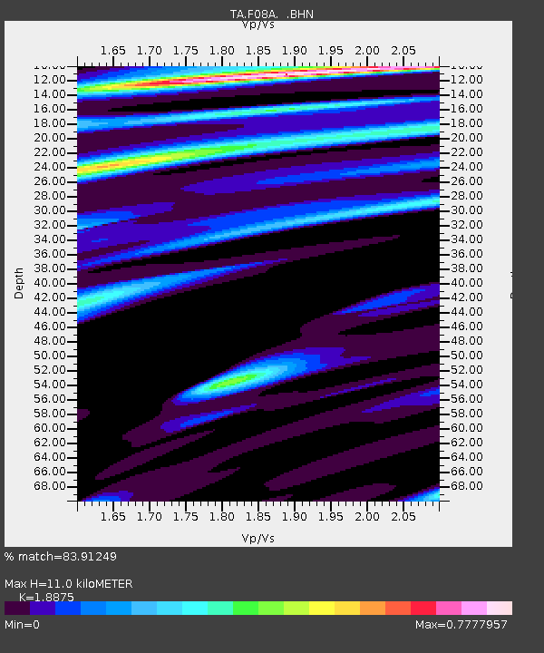
| Estimated Moho Depth: |
11.0 km |
| Estimated Crust Vp/Vs: |
1.89 |
| Assumed Crust Vp: |
6.571 km/s |
| Estimated Crust Vs: |
3.481 km/s |
| Estimated Crust Poisson's Ratio: |
0.30 |
|
| Radial Match: |
83.91249 % |
| Radial Bump: |
387 |
| Transverse Match: |
67.76834 % |
| Transverse Bump: |
400 |
| SOD ConfigId: |
2564 |
| Insert Time: |
2010-03-07 02:01:30.829 +0000 |
| GWidth: |
2.5 |
| Max Bumps: |
400 |
| Tol: |
0.001 |
|

Signal To Noise
| Channel | StoN | STA | LTA |
| TA:F08A: :BHN:20061020T10:59:35.374014Z | 0.79350764 | 2.3384744E-7 | 2.9470092E-7 |
| TA:F08A: :BHE:20061020T10:59:35.374014Z | 1.2235556 | 4.7961413E-7 | 3.9198392E-7 |
| TA:F08A: :BHZ:20061020T10:59:35.374014Z | 2.3952677 | 1.0372021E-6 | 4.3302134E-7 |
| Arrivals |
| Ps | 1.5 SECOND |
| PpPs | 4.7 SECOND |
| PsPs/PpSs | 6.2 SECOND |


