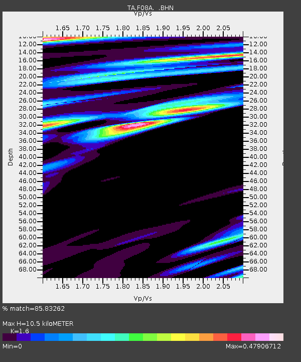
F08A Pendleton, OR, USA - Earthquake Result Viewer
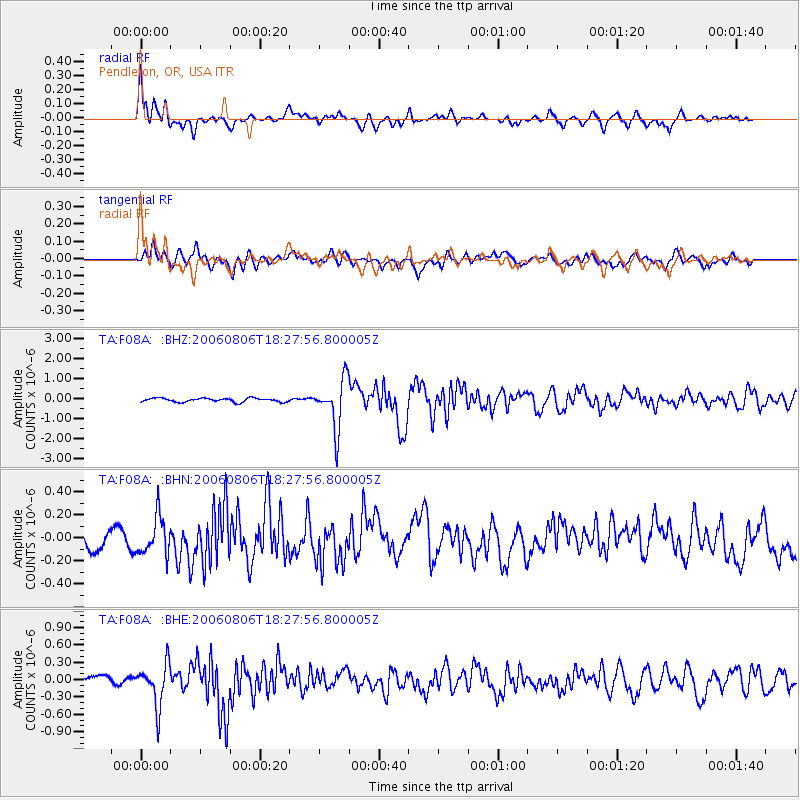
Earthquake location: Bonin Islands, Japan Region
Earthquake latitude/longitude: 26.1/144.0
Earthquake time(UTC): 2006/08/06 (218) 18:16:40 GMT
Earthquake Depth: 23 km
Earthquake Magnitude: 6.0 MB, 5.6 MS, 5.8 MW, 5.8 MW
Earthquake Catalog/Contributor: WHDF/NEIC
Network: TA USArray Transportable Network (new EarthScope stations)
Station: F08A Pendleton, OR, USA
Lat/Lon: 45.80 N/118.78 W
Elevation: 487 m
Distance: 76.5 deg
Az: 45.55 deg
Baz: 293.457 deg
Ray Param: 0.050944272
Estimated Moho Depth: 10.5 km
Estimated Crust Vp/Vs: 1.60
Assumed Crust Vp: 6.571 km/s
Estimated Crust Vs: 4.107 km/s
Estimated Crust Poisson's Ratio: 0.18
Radial Match: 85.83262 %
Radial Bump: 400
Transverse Match: 80.64345 %
Transverse Bump: 400
SOD ConfigId: 5423
Insert Time: 2010-03-07 02:01:32.230 +0000
GWidth: 2.5
Max Bumps: 400
Tol: 0.001

Signal To Noise

ChannelStoNSTALTA
TA:F08A: :BHN:20060806T18:27:56.800005Z1.95527111.6327375E-78.35044E-8
TA:F08A: :BHE:20060806T18:27:56.800005Z4.36965273.5842655E-78.202632E-8
TA:F08A: :BHZ:20060806T18:27:56.800005Z13.0981771.2231458E-69.33829E-8
Arrivals
Ps1.0 SECOND
PpPs4.0 SECOND
PsPs/PpSs5.0 SECOND