You are here: Home > Network List > TA - USArray Transportable Network (new EarthScope stations) Stations List
> Station F08A Pendleton, OR, USA > Earthquake Result Viewer
F08A Pendleton, OR, USA - Earthquake Result Viewer
| Earthquake location: |
Solomon Islands |
| Earthquake latitude/longitude: |
-6.8/155.5 |
| Earthquake time(UTC): |
2006/09/01 (244) 10:18:51 GMT |
| Earthquake Depth: |
38 km |
| Earthquake Magnitude: |
6.3 MB, 6.7 MS, 6.8 MW, 6.7 MW |
| Earthquake Catalog/Contributor: |
WHDF/NEIC |
|
| Network: |
TA USArray Transportable Network (new EarthScope stations) |
| Station: |
F08A Pendleton, OR, USA |
| Lat/Lon: |
45.80 N/118.78 W |
| Elevation: |
487 m |
|
| Distance: |
91.8 deg |
| Az: |
44.266 deg |
| Baz: |
262.245 deg |
| Ray Param: |
0.041542754 |
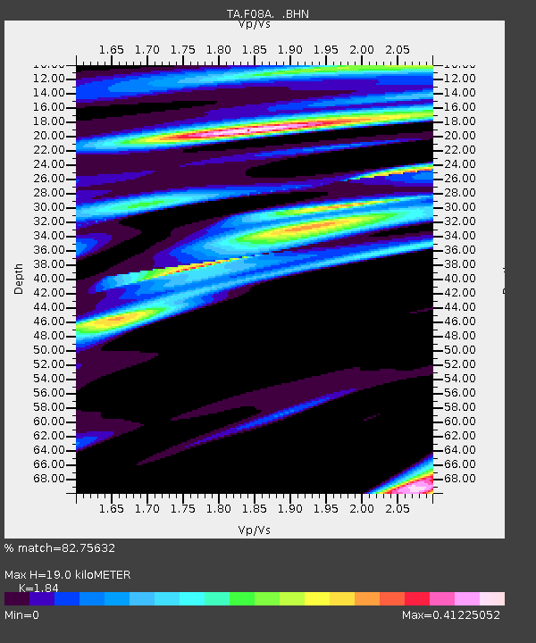
| Estimated Moho Depth: |
19.0 km |
| Estimated Crust Vp/Vs: |
1.84 |
| Assumed Crust Vp: |
6.571 km/s |
| Estimated Crust Vs: |
3.571 km/s |
| Estimated Crust Poisson's Ratio: |
0.29 |
|
| Radial Match: |
82.75632 % |
| Radial Bump: |
400 |
| Transverse Match: |
53.941223 % |
| Transverse Bump: |
400 |
| SOD ConfigId: |
2665 |
| Insert Time: |
2010-03-07 02:01:36.794 +0000 |
| GWidth: |
2.5 |
| Max Bumps: |
400 |
| Tol: |
0.001 |
|

Signal To Noise
| Channel | StoN | STA | LTA |
| TA:F08A: :BHN:20060901T10:31:24.250024Z | 0.5389578 | 9.118393E-8 | 1.6918567E-7 |
| TA:F08A: :BHE:20060901T10:31:24.250024Z | 2.705935 | 3.456149E-7 | 1.2772476E-7 |
| TA:F08A: :BHZ:20060901T10:31:24.250024Z | 7.2859197 | 1.1387214E-6 | 1.5629068E-7 |
| Arrivals |
| Ps | 2.5 SECOND |
| PpPs | 8.0 SECOND |
| PsPs/PpSs | 11 SECOND |


