You are here: Home > Network List > TA - USArray Transportable Network (new EarthScope stations) Stations List
> Station F08A Pendleton, OR, USA > Earthquake Result Viewer
F08A Pendleton, OR, USA - Earthquake Result Viewer

| Earthquake location: |
Vanuatu Islands |
| Earthquake latitude/longitude: |
-15.8/167.8 |
| Earthquake time(UTC): |
2006/08/07 (219) 22:18:54 GMT |
| Earthquake Depth: |
141 km |
| Earthquake Magnitude: |
6.0 MB, 6.8 MW, 6.8 MW |
| Earthquake Catalog/Contributor: |
WHDF/NEIC |
|
| Network: |
TA USArray Transportable Network (new EarthScope stations) |
| Station: |
F08A Pendleton, OR, USA |
| Lat/Lon: |
45.80 N/118.78 W |
| Elevation: |
487 m |
|
| Distance: |
90.1 deg |
| Az: |
42.108 deg |
| Baz: |
247.338 deg |
| Ray Param: |
0.04167171 |
| Estimated Moho Depth: |
33.0 km |
| Estimated Crust Vp/Vs: |
1.91 |
| Assumed Crust Vp: |
6.571 km/s |
| Estimated Crust Vs: |
3.431 km/s |
| Estimated Crust Poisson's Ratio: |
0.31 |
|
| Radial Match: |
87.47769 % |
| Radial Bump: |
400 |
| Transverse Match: |
71.430305 % |
| Transverse Bump: |
400 |
| SOD ConfigId: |
2665 |
| Insert Time: |
2010-03-07 02:01:43.313 +0000 |
| GWidth: |
2.5 |
| Max Bumps: |
400 |
| Tol: |
0.001 |
|
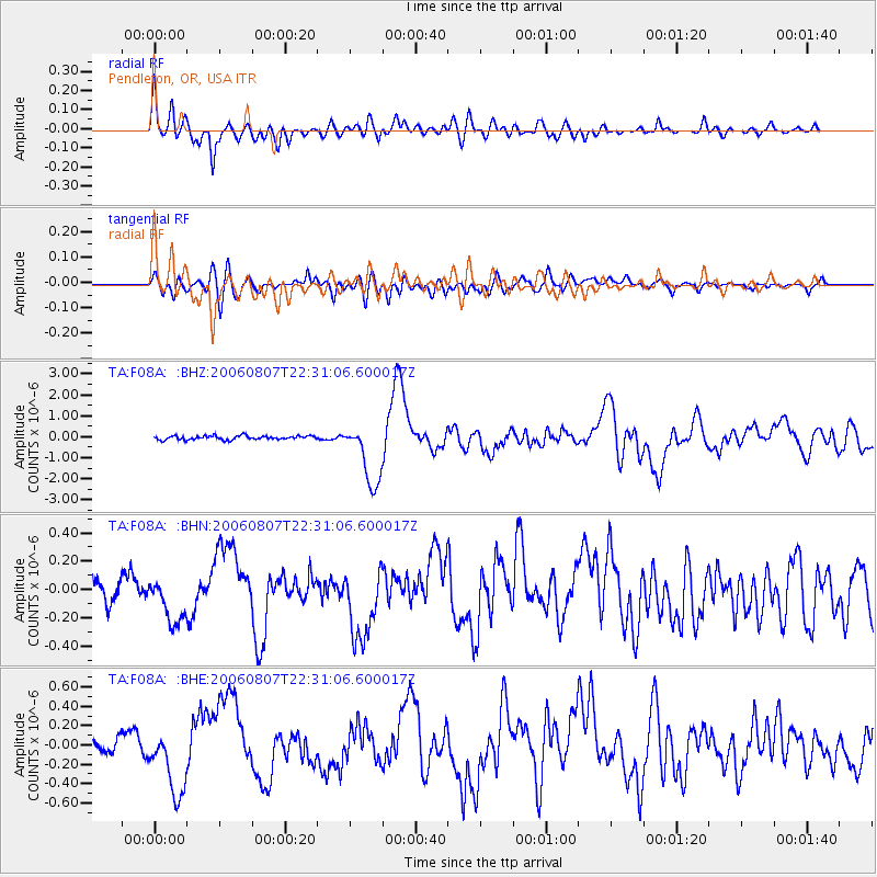
Signal To Noise
| Channel | StoN | STA | LTA |
| TA:F08A: :BHN:20060807T22:31:06.600017Z | 1.4132774 | 1.6857062E-7 | 1.192764E-7 |
| TA:F08A: :BHE:20060807T22:31:06.600017Z | 3.0678043 | 3.5494926E-7 | 1.1570141E-7 |
| TA:F08A: :BHZ:20060807T22:31:06.600017Z | 16.549665 | 1.516012E-6 | 9.160379E-8 |
| Arrivals |
| Ps | 4.7 SECOND |
| PpPs | 14 SECOND |
| PsPs/PpSs | 19 SECOND |


