You are here: Home > Network List > TA - USArray Transportable Network (new EarthScope stations) Stations List
> Station H31M Peel River, Yukon, CAN > Earthquake Result Viewer
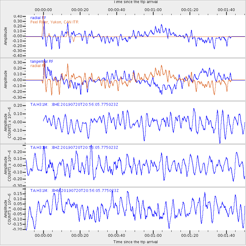
H31M Peel River, Yukon, CAN - Earthquake Result Viewer
*The percent match for this event was below the threshold and hence no stack was calculated.
| Earthquake location: |
New Britain Region, P.N.G. |
| Earthquake latitude/longitude: |
-6.0/149.5 |
| Earthquake time(UTC): |
2019/07/20 (201) 20:43:44 GMT |
| Earthquake Depth: |
60 km |
| Earthquake Magnitude: |
5.6 Mww |
| Earthquake Catalog/Contributor: |
NEIC PDE/us |
|
| Network: |
TA USArray Transportable Network (new EarthScope stations) |
| Station: |
H31M Peel River, Yukon, CAN |
| Lat/Lon: |
65.81 N/134.34 W |
| Elevation: |
642 m |
|
| Distance: |
89.8 deg |
| Az: |
23.588 deg |
| Baz: |
254.943 deg |
| Ray Param: |
$rayparam |
*The percent match for this event was below the threshold and hence was not used in the summary stack. |
|
| Radial Match: |
50.947678 % |
| Radial Bump: |
400 |
| Transverse Match: |
44.01875 % |
| Transverse Bump: |
400 |
| SOD ConfigId: |
19053131 |
| Insert Time: |
2019-08-03 20:48:51.210 +0000 |
| GWidth: |
2.5 |
| Max Bumps: |
400 |
| Tol: |
0.001 |
|
Signal To Noise
| Channel | StoN | STA | LTA |
| TA:H31M: :BHZ:20190720T20:56:05.775023Z | 1.88243 | 1.2115385E-7 | 6.436035E-8 |
| TA:H31M: :BHN:20190720T20:56:05.775023Z | 0.79476225 | 6.987352E-8 | 8.7917506E-8 |
| TA:H31M: :BHE:20190720T20:56:05.775023Z | 1.0312319 | 6.867255E-8 | 6.6592726E-8 |
| Arrivals |
| Ps | |
| PpPs | |
| PsPs/PpSs | |


