You are here: Home > Network List > TA - USArray Transportable Network (new EarthScope stations) Stations List
> Station D23K Nanushuk River, AK USA > Earthquake Result Viewer
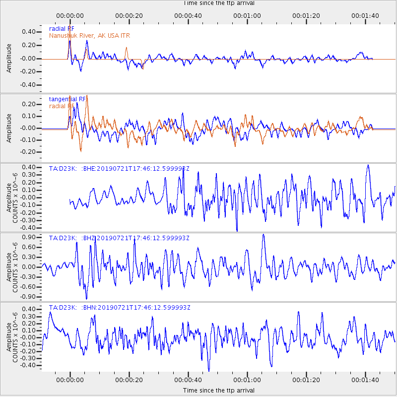
D23K Nanushuk River, AK USA - Earthquake Result Viewer
*The percent match for this event was below the threshold and hence no stack was calculated.
| Earthquake location: |
South Of Mariana Islands |
| Earthquake latitude/longitude: |
12.3/144.4 |
| Earthquake time(UTC): |
2019/07/21 (202) 17:35:38 GMT |
| Earthquake Depth: |
48 km |
| Earthquake Magnitude: |
5.5 mb |
| Earthquake Catalog/Contributor: |
NEIC PDE/us |
|
| Network: |
TA USArray Transportable Network (new EarthScope stations) |
| Station: |
D23K Nanushuk River, AK USA |
| Lat/Lon: |
68.97 N/150.68 W |
| Elevation: |
406 m |
|
| Distance: |
69.7 deg |
| Az: |
20.398 deg |
| Baz: |
250.679 deg |
| Ray Param: |
$rayparam |
*The percent match for this event was below the threshold and hence was not used in the summary stack. |
|
| Radial Match: |
66.0931 % |
| Radial Bump: |
400 |
| Transverse Match: |
51.536884 % |
| Transverse Bump: |
400 |
| SOD ConfigId: |
19053131 |
| Insert Time: |
2019-08-04 17:41:32.503 +0000 |
| GWidth: |
2.5 |
| Max Bumps: |
400 |
| Tol: |
0.001 |
|
Signal To Noise
| Channel | StoN | STA | LTA |
| TA:D23K: :BHZ:20190721T17:46:12.599993Z | 3.2075298 | 3.4096558E-7 | 1.0630161E-7 |
| TA:D23K: :BHN:20190721T17:46:12.599993Z | 0.68003815 | 1.2047738E-7 | 1.7716269E-7 |
| TA:D23K: :BHE:20190721T17:46:12.599993Z | 1.7131748 | 1.2495013E-7 | 7.2934846E-8 |
| Arrivals |
| Ps | |
| PpPs | |
| PsPs/PpSs | |


